Asūbulaq geodata
Asūbulaq (East Kazakhstan) is a populated place; located in Kazakhstan in Asia/Almaty (GMT+5) time zone. With population of 5,644 people, there are 179 cities with bigger population in this country. Compared to other cities in Kazakhstan, 56.7% of cities are located further ↓South; 96.3% of cities are located further ←West and 86.3% of cities have lower elevation than Asūbulaq. Note1


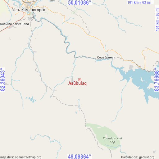
Asūbulaq GPS coordinates[2]
49° 33' 24.768" North, 83° 3' 48.78" East
| Map corner | latitude | longitude |
|---|---|---|
| Upper-left | 50.01086°, | 82.36043° |
| Center: | 49.55688°, | 83.06355° |
| Lower-right: | 49.09864°, | 83.76668° |
| Map W x H: | 101.4×101.4 km | = 63×63mi |
| max Lat: | 54.90596° ⇑43.3% North |
| Asūbulaq: | 49.55688° |
| min Lat: | ⇓56.7% South 40.66338° |
| min Long | Asūbulaq | max Long |
| 46.83361° | 83.06355° | 84.87144° |
| W 96.3%⇐ | ⇒3.7% E |
Elevation
Elevation of Asūbulaq is 645 m = 2116 ft, and this is 288.5 m = 947 ft above average elevation for this country.
| Max E: |
1847 m = 6060 ft | 13.7% |
| Asūbulaq | 645 m 2116 ft | |
| Avg. | 356.5 m = 1170 ft | |
Min E: |
-26 m = -85 ft | 86.3% |
See also: Kazakhstan elevation on elevation.city.
Geographical zone
Asūbulaq is located in North temperate zone (between Tropic of Cancer and the Arctic Circle). Distance of this North polar circle is 1891 km =1175 mi to North.| Distance of | km | miles | from Asūbulaq |
|---|---|---|---|
| North Pole | 4496.9 | 2794.2 | to North |
| Arctic Circle | 1891 | 1175 | to North |
| Tropic Cancer | 2904.3 | 1804.6 | to South |
| Equator | 5510.2 | 3423.9 | to South |


Nearby cities:
15 places around Asūbulaq: (largest is in red/bold)
• Aksuat
104.3 km =64.8 mi,  153°
153°
• Altayskiy
91.6 km =56.9 mi,  326°
326°
• Auezov
108.2 km =67.2 mi,  279°
279°
• Belogorskīy
10.8 km =6.7 mi, 145°
• Belousovka
74.8 km =46.5 mi, 328°
• Georgīevka
110.7 km =68.8 mi,  256°
256°
• Glubokoye
84.2 km =52.3 mi,  320°
320°
• Kokpekty
101.9 km =63.3 mi,  208°
208°
• Maleyevsk
92.8 km =57.7 mi,  72°
72°
• Ognevka
14.5 km =9 mi,  346°
346°
• Pervorosiyskiy
59.3 km =36.8 mi, 72°
• Ridder
93.2 km =57.9 mi,  20°
20°
• Ust-Kamenogorsk
56.6 km =35.2 mi, 324°
• Zhanga Buqtyrma
34.2 km =21.3 mi,  76°
76°
• Zyryanovsk
89.1 km =55.4 mi, 77°
Sources, notices
• [Note1] Compared only with cities in Kazakhstan existing in our database
• [Src1] Map data: © OpenStreetMap contributors (CC-BY-SA)
• [Src2] Other city data from geonames.org with taken over terms of usage.
• [Src3] Geographical zone / Annual Mean Temperature by Robert A. Rohde @ Wikipedia
