Ridder geodata
Ridder (East Kazakhstan) is a populated place; located in Kazakhstan in Asia/Almaty (GMT+5) time zone. With population of 52,664 people, there are 27 cities with bigger population in this country. Compared to other cities in Kazakhstan, 70% of cities are located further ↓South; 97% of cities are located further ←West and 91.5% of cities have lower elevation than Ridder. Note1


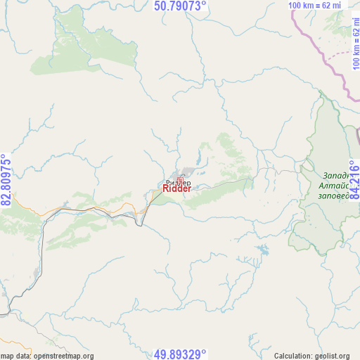
Ridder GPS coordinates[2]
50° 20' 38.868" North, 83° 30' 46.332" East
| Map corner | latitude | longitude |
|---|---|---|
| Upper-left | 50.79073°, | 82.80975° |
| Center: | 50.34413°, | 83.51287° |
| Lower-right: | 49.89329°, | 84.216° |
| Map W x H: | 99.8×99.8 km | = 62×62mi |
| max Lat: | 54.90596° ⇑30% North |
| Ridder: | 50.34413° |
| min Lat: | ⇓70% South 40.66338° |
| min Long | Ridder | max Long |
| 46.83361° | 83.51287° | 84.87144° |
| W 97%⇐ | ⇒3% E |
Elevation
Elevation of Ridder is 741 m = 2431 ft, and this is 384.5 m = 1261 ft above average elevation for this country.
| Max E: |
1847 m = 6060 ft | 8.5% |
| Ridder | 741 m 2431 ft | |
| Avg. | 356.5 m = 1170 ft | |
Min E: |
-26 m = -85 ft | 91.5% |
See also: Ridder elevation on elevation.city.
Geographical zone
Ridder is located in North temperate zone (between Tropic of Cancer and the Arctic Circle). Distance of this North polar circle is 1803.4 km =1120.6 mi to North.| Distance of | km | miles | from Ridder |
|---|---|---|---|
| North Pole | 4409.3 | 2739.8 | to North |
| Arctic Circle | 1803.4 | 1120.6 | to North |
| Tropic Cancer | 2991.8 | 1859 | to South |
| Equator | 5597.7 | 3478.2 | to South |


Nearby cities:
15 places around Ridder: (largest is in red/bold)
• Altayskiy
82.4 km =51.2 mi,  262°
262°
• Asūbulaq
93.2 km =57.9 mi,  200°
200°
• Auezov
155 km =96.3 mi,  242°
242°
• Belogorskīy
99.9 km =62.1 mi, 195°
• Belousovka
74.1 km =46 mi,  251°
251°
• Glubokoye
88.5 km =55 mi, 255°
• Maleyevsk
80.9 km =50.3 mi,  136°
136°
• Ognevka
81.6 km =50.7 mi,  205°
205°
• Pervorosiyskiy
73.8 km =45.9 mi,  161°
161°
• Shemonaīkha
117.6 km =73.1 mi,  285°
285°
• Ust-Kamenogorsk
76.8 km =47.7 mi, 237°
• Zhanga Buqtyrma
79.5 km =49.4 mi,  179°
179°
• Zhezkent
165.1 km =102.6 mi, 293°
• Zyryanovsk
87.5 km =54.4 mi, 141°
• Ūst’-Talovka
119.9 km =74.5 mi,  280°
280°
Sources, notices
• [Note1] Compared only with cities in Kazakhstan existing in our database
• [Src1] Map data: © OpenStreetMap contributors (CC-BY-SA)
• [Src2] Other city data from geonames.org with taken over terms of usage.
• [Src3] Geographical zone / Annual Mean Temperature by Robert A. Rohde @ Wikipedia
