Yermentau geodata
Yermentau (Aqmola) is a populated place; located in Kazakhstan in Asia/Almaty (GMT+5) time zone. With population of 14,169 people, there are 82 cities with bigger population in this country. Compared to other cities in Kazakhstan, 79.3% of cities are located further ↓South; 65.6% of cities are located further ←West and 60% of cities have lower elevation than Yermentau. Note1


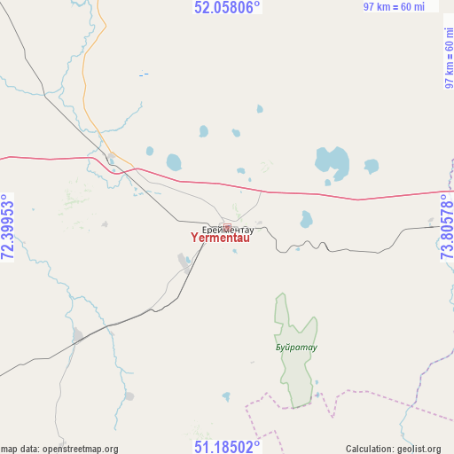
Yermentau GPS coordinates[2]
51° 37' 25.104" North, 73° 6' 9.54" East
| Map corner | latitude | longitude |
|---|---|---|
| Upper-left | 52.05806°, | 72.39953° |
| Center: | 51.62364°, | 73.10265° |
| Lower-right: | 51.18502°, | 73.80578° |
| Map W x H: | 97.1×97.1 km | = 60.3×60.3mi |
| max Lat: | 54.90596° ⇑20.7% North |
| Yermentau: | 51.62364° |
| min Lat: | ⇓79.3% South 40.66338° |
| min Long | Yermentau | max Long |
| 46.83361° | 73.10265° | 84.87144° |
| W 65.6%⇐ | ⇒34.4% E |
Elevation
Elevation of Yermentau is 392 m = 1286 ft, and this is 35.5 m = 116 ft above average elevation for this country.
| Max E: |
1847 m = 6060 ft | 40% |
| Yermentau | 392 m 1286 ft | |
| Avg. | 356.5 m = 1170 ft | |
Min E: |
-26 m = -85 ft | 60% |
See also: Kazakhstan elevation on elevation.city.
Geographical zone
Yermentau is located in North temperate zone (between Tropic of Cancer and the Arctic Circle). Distance of this North polar circle is 1661.2 km =1032.2 mi to North.| Distance of | km | miles | from Yermentau |
|---|---|---|---|
| North Pole | 4267.1 | 2651.5 | to North |
| Arctic Circle | 1661.2 | 1032.2 | to North |
| Tropic Cancer | 3134.1 | 1947.4 | to South |
| Equator | 5740 | 3566.7 | to South |


Nearby cities:
15 places around Yermentau: (largest is in red/bold)
• Akkol
153.8 km =95.6 mi,  285°
285°
• Aksu
120.2 km =74.7 mi,  319°
319°
• Aktau
154.5 km =96 mi,  180°
180°
• Bestobe
97.2 km =60.4 mi,  359°
359°
• Ekibastuz
153.5 km =95.4 mi,  85°
85°
• Kushoky
156.3 km =97.1 mi,  172°
172°
• Kyzylzhar
185.8 km =115.5 mi,  190°
190°
• Nur-Sultan
125 km =77.7 mi,  246°
246°
• Osakarovka
123.7 km =76.9 mi,  197°
197°
• Shortandy
145.6 km =90.5 mi,  273°
273°
• Stepnogorsk
116.3 km =72.3 mi,  314°
314°
• Temirtau
174.7 km =108.6 mi, 183°
• Tokarevka
167.7 km =104.2 mi, 178°
• Zavodskoy
120 km =74.6 mi, 321°
• Zholymbet
96.7 km =60.1 mi,  277°
277°
Sources, notices
• [Note1] Compared only with cities in Kazakhstan existing in our database
• [Src1] Map data: © OpenStreetMap contributors (CC-BY-SA)
• [Src2] Other city data from geonames.org with taken over terms of usage.
• [Src3] Geographical zone / Annual Mean Temperature by Robert A. Rohde @ Wikipedia
