Shortandy geodata
Shortandy (Aqmola) is a populated place; located in Kazakhstan in Asia/Almaty (GMT+5) time zone. With population of 6,980 people, there are 154 cities with bigger population in this country. Compared to other cities in Kazakhstan, 79.6% of cities are located further ↓South; 53.3% of cities are located further ←West and 57.4% of cities have lower elevation than Shortandy. Note1


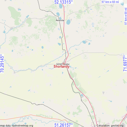
Shortandy GPS coordinates[2]
51° 41' 58.056" North, 70° 59' 40.452" East
| Map corner | latitude | longitude |
|---|---|---|
| Upper-left | 52.13315°, | 70.29145° |
| Center: | 51.69946°, | 70.99457° |
| Lower-right: | 51.26157°, | 71.6977° |
| Map W x H: | 96.9×96.9 km | = 60.2×60.2mi |
| max Lat: | 54.90596° ⇑20.4% North |
| Shortandy: | 51.69946° |
| min Lat: | ⇓79.6% South 40.66338° |
| min Long | Shortandy | max Long |
| 46.83361° | 70.99457° | 84.87144° |
| W 53.3%⇐ | ⇒46.7% E |
Elevation
Elevation of Shortandy is 375 m = 1230 ft, and this is 18.5 m = 61 ft above average elevation for this country.
| Max E: |
1847 m = 6060 ft | 42.6% |
| Shortandy | 375 m 1230 ft | |
| Avg. | 356.5 m = 1170 ft | |
Min E: |
-26 m = -85 ft | 57.4% |
See also: Kazakhstan elevation on elevation.city.
Geographical zone
Shortandy is located in North temperate zone (between Tropic of Cancer and the Arctic Circle). Distance of this North polar circle is 1652.7 km =1026.9 mi to North.| Distance of | km | miles | from Shortandy |
|---|---|---|---|
| North Pole | 4258.6 | 2646.2 | to North |
| Arctic Circle | 1652.7 | 1026.9 | to North |
| Tropic Cancer | 3142.5 | 1952.7 | to South |
| Equator | 5748.4 | 3571.9 | to South |


Nearby cities:
15 places around Shortandy: (largest is in red/bold)
• Akkol
32.9 km =20.4 mi,  354°
354°
• Aksu
105.8 km =65.7 mi,  38°
38°
• Astrakhan
84.8 km =52.7 mi,  257°
257°
• Būrabay
160.7 km =99.9 mi,  343°
343°
• Egindiköl
127.3 km =79.1 mi,  235°
235°
• Kīevka
164.5 km =102.2 mi,  166°
166°
• Makinsk
111 km =69 mi, 339°
• Nur-Sultan
65.7 km =40.8 mi,  151°
151°
• Osakarovka
167.6 km =104.1 mi,  138°
138°
• Shchuchinsk
148 km =92 mi, 338°
• Stepnogorsk
94.5 km =58.7 mi, 39°
• Stepnyak
127 km =78.9 mi, 353°
• Yermentau
145.6 km =90.5 mi,  93°
93°
• Zavodskoy
110.5 km =68.7 mi, 39°
• Zholymbet
49.7 km =30.9 mi,  84°
84°
Sources, notices
• [Note1] Compared only with cities in Kazakhstan existing in our database
• [Src1] Map data: © OpenStreetMap contributors (CC-BY-SA)
• [Src2] Other city data from geonames.org with taken over terms of usage.
• [Src3] Geographical zone / Annual Mean Temperature by Robert A. Rohde @ Wikipedia
