Ekibastuz geodata
Ekibastuz (Pavlodar Region) is a populated place; located in Kazakhstan in Asia/Almaty (GMT+5) time zone. With population of 121,470 people, there are 18 cities with bigger population in this country. Compared to other cities in Kazakhstan, 80% of cities are located further ↓South; 74.1% of cities are located further ←West and 65.6% of cities have higher elevation than Ekibastuz. Note1


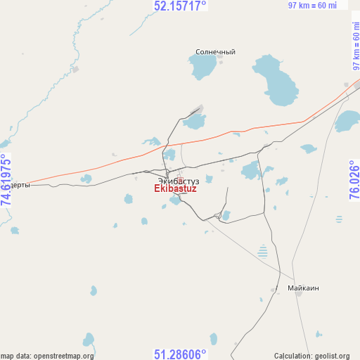
Ekibastuz GPS coordinates[2]
51° 43' 25.356" North, 75° 19' 22.332" East
| Map corner | latitude | longitude |
|---|---|---|
| Upper-left | 52.15717°, | 74.61975° |
| Center: | 51.72371°, | 75.32287° |
| Lower-right: | 51.28606°, | 76.026° |
| Map W x H: | 96.9×96.9 km | = 60.2×60.2mi |
| max Lat: | 54.90596° ⇑20% North |
| Ekibastuz: | 51.72371° |
| min Lat: | ⇓80% South 40.66338° |
| min Long | Ekibastuz | max Long |
| 46.83361° | 75.32287° | 84.87144° |
| W 74.1%⇐ | ⇒25.9% E |
Elevation
Elevation of Ekibastuz is 203 m = 666 ft, and this is 153.5 m = 504 ft below average elevation for this country.
| Max E: |
1847 m = 6060 ft | 65.6% |
| Avg. | 356.5 m = 1170 ft | |
| Ekibastuz | 203 m = 666 ft | |
Min E: |
-26 m = -85 ft | 34.4% |
See also: Ekibastuz elevation on elevation.city.
Geographical zone
Ekibastuz is located in North temperate zone (between Tropic of Cancer and the Arctic Circle). Distance of this North polar circle is 1650 km =1025.3 mi to North.| Distance of | km | miles | from Ekibastuz |
|---|---|---|---|
| North Pole | 4255.9 | 2644.5 | to North |
| Arctic Circle | 1650 | 1025.3 | to North |
| Tropic Cancer | 3145.2 | 1954.3 | to South |
| Equator | 5751.1 | 3573.6 | to South |


Nearby cities:
15 places around Ekibastuz: (largest is in red/bold)
• Aksu
115.6 km =71.8 mi,  72°
72°
• Aktau
228.8 km =142.2 mi,  223°
223°
• Bayanaul
106.8 km =66.4 mi,  165°
165°
• Belogor’ye
149.9 km =93.1 mi,  98°
98°
• Bestobe
174.7 km =108.6 mi,  299°
299°
• Irtyshsk
179.2 km =111.3 mi,  2°
2°
• Kalkaman
54.7 km =34 mi,  62°
62°
• Kushoky
213.6 km =132.7 mi, 219°
• Leninskiy
116 km =72.1 mi, 59°
• Mayqayyng
44.2 km =27.5 mi,  131°
131°
• Pavlodar
128.6 km =79.9 mi, 61°
• Prigorodnoye
226.6 km =140.8 mi,  175°
175°
• Qashyr
158.4 km =98.4 mi,  19°
19°
• Yermentau
153.5 km =95.4 mi,  265°
265°
• Zhelezinka
201.8 km =125.4 mi,  359°
359°
In other languages:
- In France: Ekibastouz
- In German: Ekibastus
- In Italian: Ekibastūz
- In Russian: Экибастуз
- In Chinese: 埃基巴斯圖茲
Sources, notices
• [Note1] Compared only with cities in Kazakhstan existing in our database
• [Src1] Map data: © OpenStreetMap contributors (CC-BY-SA)
• [Src2] Other city data from geonames.org with taken over terms of usage.
• [Src3] Geographical zone / Annual Mean Temperature by Robert A. Rohde @ Wikipedia
