Akkol geodata
Akkol (Aqmola) is a seat of a second-order administrative division; located in Kazakhstan in Asia/Almaty (GMT+5) time zone. With population of 2,605 people, there are 235 cities with bigger population in this country. Compared to other cities in Kazakhstan, 82.6% of cities are located further ↓South; 53% of cities are located further ←West and 58.9% of cities have lower elevation than Akkol. Note1


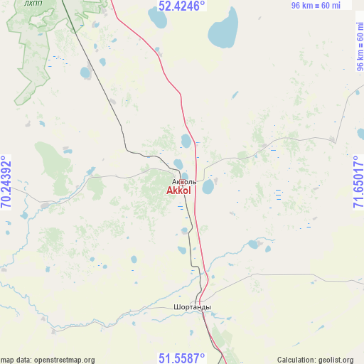
Akkol GPS coordinates[2]
51° 59' 37.464" North, 70° 56' 49.344" East
| Map corner | latitude | longitude |
|---|---|---|
| Upper-left | 52.4246°, | 70.24392° |
| Center: | 51.99374°, | 70.94704° |
| Lower-right: | 51.5587°, | 71.65017° |
| Map W x H: | 96.3×96.3 km | = 59.8×59.8mi |
| max Lat: | 54.90596° ⇑17.4% North |
| Akkol: | 51.99374° |
| min Lat: | ⇓82.6% South 40.66338° |
| min Long | Akkol | max Long |
| 46.83361° | 70.94704° | 84.87144° |
| W 53%⇐ | ⇒47% E |
Elevation
Elevation of Akkol is 381 m = 1250 ft, and this is 24.5 m = 80 ft above average elevation for this country.
| Max E: |
1847 m = 6060 ft | 41.1% |
| Akkol | 381 m 1250 ft | |
| Avg. | 356.5 m = 1170 ft | |
Min E: |
-26 m = -85 ft | 58.9% |
See also: Kazakhstan elevation on elevation.city.
Geographical zone
Akkol is located in North temperate zone (between Tropic of Cancer and the Arctic Circle). Distance of this North polar circle is 1620 km =1006.6 mi to North.| Distance of | km | miles | from Akkol |
|---|---|---|---|
| North Pole | 4225.9 | 2625.9 | to North |
| Arctic Circle | 1620 | 1006.6 | to North |
| Tropic Cancer | 3175.2 | 1973 | to South |
| Equator | 5781.2 | 3592.3 | to South |


Nearby cities:
15 places around Akkol: (largest is in red/bold)
• Aksu
85.1 km =52.9 mi,  53°
53°
• Astrakhan
94.4 km =58.7 mi,  236°
236°
• Balkashino
160.4 km =99.7 mi,  291°
291°
• Bestobe
156.7 km =97.4 mi,  69°
69°
• Būrabay
128.5 km =79.8 mi,  340°
340°
• Egindiköl
145.7 km =90.5 mi,  224°
224°
• Makinsk
79.6 km =49.5 mi,  333°
333°
• Nur-Sultan
96.8 km =60.1 mi,  159°
159°
• Shchuchinsk
116.7 km =72.5 mi, 333°
• Shortandy
32.9 km =20.4 mi,  174°
174°
• Stepnogorsk
75.1 km =46.7 mi,  58°
58°
• Stepnyak
94.1 km =58.5 mi,  353°
353°
• Yermentau
153.8 km =95.6 mi,  105°
105°
• Zavodskoy
90 km =55.9 mi, 53°
• Zholymbet
59.5 km =37 mi,  118°
118°
Sources, notices
• [Note1] Compared only with cities in Kazakhstan existing in our database
• [Src1] Map data: © OpenStreetMap contributors (CC-BY-SA)
• [Src2] Other city data from geonames.org with taken over terms of usage.
• [Src3] Geographical zone / Annual Mean Temperature by Robert A. Rohde @ Wikipedia
