Egindiköl geodata
Egindiköl (Aqmola) is a populated place; located in Kazakhstan in Asia/Almaty (GMT+5) time zone. With population of 3,751 people, there are 216 cities with bigger population in this country. Compared to other cities in Kazakhstan, 74.1% of cities are located further ↓South; 55.6% of cities are located further →East and 51.5% of cities have lower elevation than Egindiköl. Note1


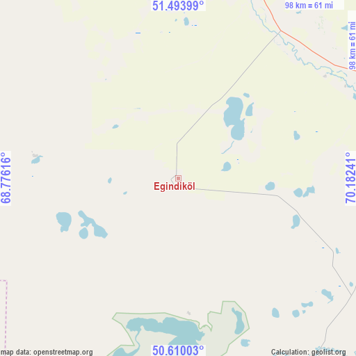
Egindiköl GPS coordinates[2]
51° 3' 14.832" North, 69° 28' 45.408" East
| Map corner | latitude | longitude |
|---|---|---|
| Upper-left | 51.49399°, | 68.77616° |
| Center: | 51.05412°, | 69.47928° |
| Lower-right: | 50.61003°, | 70.18241° |
| Map W x H: | 98.3×98.3 km | = 61.1×61.1mi |
| max Lat: | 54.90596° ⇑25.9% North |
| Egindiköl: | 51.05412° |
| min Lat: | ⇓74.1% South 40.66338° |
| min Long | Egindiköl | max Long |
| 46.83361° | 69.47928° | 84.87144° |
| W 44.4%⇐ | ⇒55.6% E |
Elevation
Elevation of Egindiköl is 340 m = 1115 ft, and this is 16.5 m = 54 ft below average elevation for this country.
| Max E: |
1847 m = 6060 ft | 48.5% |
| Avg. | 356.5 m = 1170 ft | |
| Egindiköl | 340 m = 1115 ft | |
Min E: |
-26 m = -85 ft | 51.5% |
See also: Kazakhstan elevation on elevation.city.
Geographical zone
Egindiköl is located in North temperate zone (between Tropic of Cancer and the Arctic Circle). Distance of this North polar circle is 1724.5 km =1071.6 mi to North.| Distance of | km | miles | from Egindiköl |
|---|---|---|---|
| North Pole | 4330.4 | 2690.8 | to North |
| Arctic Circle | 1724.5 | 1071.6 | to North |
| Tropic Cancer | 3070.8 | 1908.1 | to South |
| Equator | 5676.7 | 3527.3 | to South |


Nearby cities:
15 places around Egindiköl: (largest is in red/bold)
• Akkol
145.7 km =90.5 mi,  44°
44°
• Arkalyk
201.4 km =125.1 mi,  243°
243°
• Astrakhan
57.4 km =35.7 mi,  22°
22°
• Atbasar
114.1 km =70.9 mi,  317°
317°
• Atbasar
114.8 km =71.3 mi, 316°
• Balkashino
170.3 km =105.8 mi,  342°
342°
• Kīevka
170.4 km =105.9 mi,  121°
121°
• Makinsk
187 km =116.2 mi, 20°
• Nur-Sultan
138 km =85.7 mi,  84°
84°
• Shantobe
179.7 km =111.7 mi,  330°
330°
• Shchuchinsk
214.8 km =133.5 mi,  13°
13°
• Shortandy
127.3 km =79.1 mi,  55°
55°
• Stepnyak
217.4 km =135.1 mi, 24°
• Zhaqsy
177.5 km =110.3 mi,  302°
302°
• Zholymbet
172.8 km =107.4 mi, 63°
Sources, notices
• [Note1] Compared only with cities in Kazakhstan existing in our database
• [Src1] Map data: © OpenStreetMap contributors (CC-BY-SA)
• [Src2] Other city data from geonames.org with taken over terms of usage.
• [Src3] Geographical zone / Annual Mean Temperature by Robert A. Rohde @ Wikipedia
