Sekong geodata
Sekong (Xékong) is a seat of a first-order administrative division; located in Laos in Asia/Vientiane (GMT+7) time zone. In our database, there are 24 cities with bigger population. Compared to other cities in Laos, 80.8% of cities are located further ↑North; 90.4% of cities are located further ←West and 80.8% of cities have higher elevation than Sekong. Note1


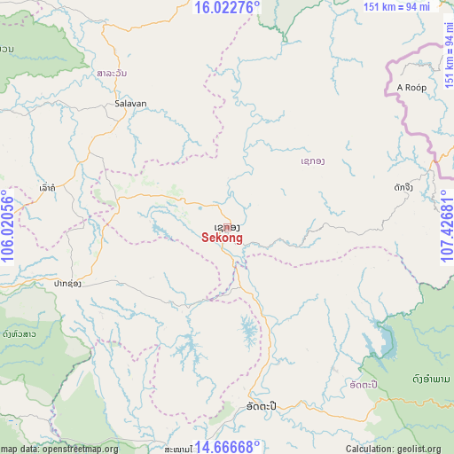
Sekong GPS coordinates[2]
15° 20' 44.952" North, 106° 43' 25.248" East
| Map corner | latitude | longitude |
|---|---|---|
| Upper-left | 16.02276°, | 106.02056° |
| Center: | 15.34582°, | 106.72368° |
| Lower-right: | 14.66668°, | 107.42681° |
| Map W x H: | 150.8×150.8 km | = 93.7×93.7mi |
| max Lat: | 21.6808° ⇑80.8% North |
| Sekong: | 15.34582° |
| min Lat: | ⇓19.2% South 14.11785° |
| min Long | Sekong | max Long |
| 100.4178° | 106.72368° | 107.26667° |
| W 90.4%⇐ | ⇒9.6% E |
Elevation
Elevation of Sekong is 148 m = 486 ft, and this is 325.6 m = 1068 ft below average elevation for this country.
| Max E: |
1722 m = 5650 ft | 80.8% |
| Avg. | 473.6 m = 1554 ft | |
| Sekong | 148 m = 486 ft | |
Min E: |
83 m = 272 ft | 19.2% |
See also: Laos elevation on elevation.city.
Geographical zone
Sekong is located in North Torrid zone (between Equator and Tropic of Cancer). Distance of this Northern Tropic circle is 899.6 km =559 mi to North.| Distance of | km | miles | from Sekong |
|---|---|---|---|
| North Pole | 8300.8 | 5157.9 | to North |
| Arctic Circle | 5694.9 | 3538.6 | to North |
| Tropic Cancer | 899.6 | 559 | to North |
| Equator | 1706.3 | 1060.2 | to South |


Nearby cities:
15 places around Sekong: (largest is in red/bold)
• Attapeu
60.6 km =37.7 mi,  168°
168°
• Ban Fangdèng
63.4 km =39.4 mi,  159°
159°
• Ban Hatgnao
75.5 km =46.9 mi,  191°
191°
• Ban Thatèng
37.8 km =23.5 mi,  284°
284°
• Champasak
103.9 km =64.6 mi,  240°
240°
• Dak Cheung
59.7 km =37.1 mi,  77°
77°
• Lamam
8.5 km =5.3 mi,  338°
338°
• Muang Không
165.5 km =102.8 mi,  214°
214°
• Muang Phin
151.8 km =94.3 mi,  330°
330°
• Pakse
102.3 km =63.6 mi,  255°
255°
• Pakxong
56 km =34.8 mi,  250°
250°
• Phônthong
117.9 km =73.3 mi, 256°
• Salavan
52.7 km =32.7 mi,  321°
321°
• Sanaxy
67.9 km =42.2 mi,  122°
122°
• Xaysetha
63.3 km =39.3 mi, 159°
Sources, notices
• [Note1] Compared only with cities in Laos existing in our database
• [Src1] Map data: © OpenStreetMap contributors (CC-BY-SA)
• [Src2] Other city data from geonames.org with taken over terms of usage.
• [Src3] Geographical zone / Annual Mean Temperature by Robert A. Rohde @ Wikipedia
