Lamam geodata
Lamam (Xékong) is a populated place; located in Laos in Asia/Vientiane (GMT+7) time zone. With population of 4,463 people, there are 19 cities with bigger population in this country. Compared to other cities in Laos, 78.8% of cities are located further ↑North; 88.5% of cities are located further ←West and 59.6% of cities have higher elevation than Lamam. Note1


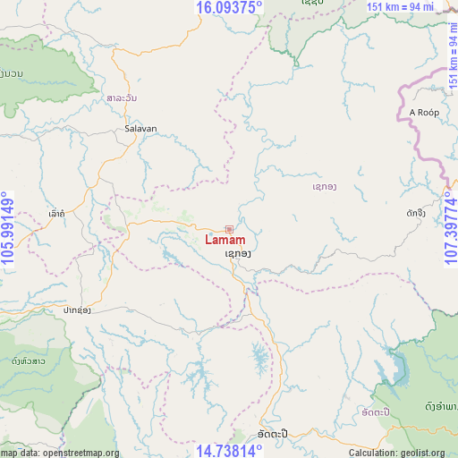
Lamam GPS coordinates[2]
15° 25' 1.38" North, 106° 41' 40.596" East
| Map corner | latitude | longitude |
|---|---|---|
| Upper-left | 16.09375°, | 105.99149° |
| Center: | 15.41705°, | 106.69461° |
| Lower-right: | 14.73814°, | 107.39774° |
| Map W x H: | 150.7×150.7 km | = 93.6×93.6mi |
| max Lat: | 21.6808° ⇑78.8% North |
| Lamam: | 15.41705° |
| min Lat: | ⇓21.2% South 14.11785° |
| min Long | Lamam | max Long |
| 100.4178° | 106.69461° | 107.26667° |
| W 88.5%⇐ | ⇒11.5% E |
Elevation
Elevation of Lamam is 199 m = 653 ft, and this is 274.6 m = 901 ft below average elevation for this country.
| Max E: |
1722 m = 5650 ft | 59.6% |
| Avg. | 473.6 m = 1554 ft | |
| Lamam | 199 m = 653 ft | |
Min E: |
83 m = 272 ft | 40.4% |
See also: Laos elevation on elevation.city.
Geographical zone
Lamam is located in North Torrid zone (between Equator and Tropic of Cancer). Distance of this Northern Tropic circle is 891.7 km =554.1 mi to North.| Distance of | km | miles | from Lamam |
|---|---|---|---|
| North Pole | 8292.8 | 5152.9 | to North |
| Arctic Circle | 5687 | 3533.7 | to North |
| Tropic Cancer | 891.7 | 554.1 | to North |
| Equator | 1714.2 | 1065.2 | to South |


Nearby cities:
15 places around Lamam: (largest is in red/bold)
• Attapeu
69 km =42.9 mi,  167°
167°
• Ban Fangdèng
71.9 km =44.7 mi,  159°
159°
• Ban Hatgnao
82.8 km =51.4 mi,  188°
188°
• Ban Thatèng
33.5 km =20.8 mi,  273°
273°
• Champasak
105.3 km =65.4 mi,  236°
236°
• Dak Cheung
61.6 km =38.3 mi,  84°
84°
• Muang Không
170.4 km =105.9 mi,  212°
212°
• Muang Phin
143.4 km =89.1 mi,  330°
330°
• Pakse
101.6 km =63.1 mi,  251°
251°
• Pakxong
56.3 km =35 mi, 242°
• Phônthong
117 km =72.7 mi, 252°
• Salavan
44.6 km =27.7 mi,  318°
318°
• Sanaxy
74.9 km =46.5 mi,  125°
125°
• Sekong
8.5 km =5.3 mi, 158°
• Xaysetha
71.8 km =44.6 mi, 158°
Sources, notices
• [Note1] Compared only with cities in Laos existing in our database
• [Src1] Map data: © OpenStreetMap contributors (CC-BY-SA)
• [Src2] Other city data from geonames.org with taken over terms of usage.
• [Src3] Geographical zone / Annual Mean Temperature by Robert A. Rohde @ Wikipedia
