Tangalle geodata
Tangalle (Southern) is a populated place; located in Sri Lanka in Asia/Colombo (GMT+5.5) time zone. With population of 10,497 people, there are 56 cities with bigger population in this country. Compared to other cities in Sri Lanka, 90.8% of cities are located further ↑North; 81.6% of cities are located further ←West and 59.2% of cities have lower elevation than Tangalle. Note1


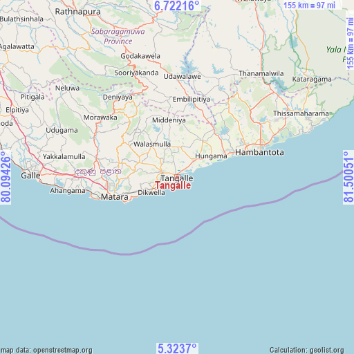
Tangalle GPS coordinates[2]
6° 1' 24.168" North, 80° 47' 50.568" East
| Map corner | latitude | longitude |
|---|---|---|
| Upper-left | 6.72216°, | 80.09426° |
| Center: | 6.02338°, | 80.79738° |
| Lower-right: | 5.3237°, | 81.50051° |
| Map W x H: | 155.5×155.5 km | = 96.6×96.6mi |
| max Lat: | 9.81667° ⇑90.8% North |
| Tangalle: | 6.02338° |
| min Lat: | ⇓9.2% South 5.92825° |
| min Long | Tangalle | max Long |
| 79.79528° | 80.79738° | 81.83472° |
| W 81.6%⇐ | ⇒18.4% E |
Elevation
Elevation of Tangalle is 22 m = 72 ft, and this is 135.4 m = 444 ft below average elevation for this country.
| Max E: |
1868 m = 6129 ft | 40.8% |
| Avg. | 157.4 m = 516 ft | |
| Tangalle | 22 m = 72 ft | |
Min E: |
1 m = 3 ft | 59.2% |
See also: Sri Lanka elevation on elevation.city.
Geographical zone
Tangalle is located in North Torrid zone (between Equator and Tropic of Cancer). Distance of Equator is 669.7 km =416.1 mi to South.| Distance of | km | miles | from Tangalle |
|---|---|---|---|
| North Pole | 9337.3 | 5801.9 | to North |
| Arctic Circle | 6731.4 | 4182.7 | to North |
| Tropic Cancer | 1936.2 | 1203.1 | to North |
| Equator | 669.7 | 416.1 | to South |


Nearby cities:
15 places around Tangalle: (largest is in red/bold)
• Ambalangoda
85.5 km =53.1 mi,  286°
286°
• Devinuwara
25.4 km =15.8 mi,  245°
245°
• Galle
65 km =40.4 mi,  272°
272°
• Haputale
84.3 km =52.4 mi,  11°
11°
• Hikkaduwa
78.1 km =48.5 mi,  279°
279°
• Horawala Junction
89.9 km =55.9 mi,  304°
304°
• Kataragama
73.5 km =45.7 mi,  53°
53°
• Koggala
52 km =32.3 mi, 265°
• Matara
30.2 km =18.8 mi, 253°
• Mirissa city
38.5 km =23.9 mi,  257°
257°
• Ratnapura
85.5 km =53.1 mi,  329°
329°
• Talpe
57.4 km =35.7 mi, 267°
• Unawatuna
60.5 km =37.6 mi, 269°
• Weligama
41 km =25.5 mi, 262°
• Wellawaya
86.2 km =53.6 mi,  23°
23°
Sources, notices
• [Note1] Compared only with cities in Sri Lanka existing in our database
• [Src1] Map data: © OpenStreetMap contributors (CC-BY-SA)
• [Src2] Other city data from geonames.org with taken over terms of usage.
• [Src3] Geographical zone / Annual Mean Temperature by Robert A. Rohde @ Wikipedia
