Chilaw geodata
Chilaw (North Western) is a populated place; located in Sri Lanka in Asia/Colombo (GMT+5.5) time zone. With population of 24,712 people, there are 44 cities with bigger population in this country. Compared to other cities in Sri Lanka, 78.9% of cities are located further ↓South; 100% of cities are located further →East and 88.2% of cities have higher elevation than Chilaw. Note1
Administrative division(s):
- Level 1: North Western
- Level 2: Puttalam District
- Level 3: Chilaw Division
- Level 4: Pitipana North


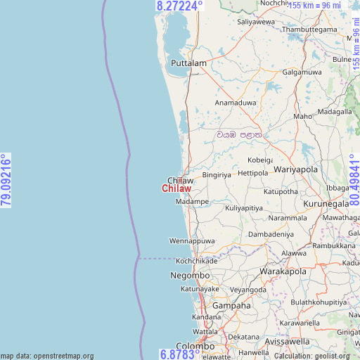
Chilaw GPS coordinates[2]
7° 34' 32.988" North, 79° 47' 43.008" East
| Map corner | latitude | longitude |
|---|---|---|
| Upper-left | 8.27224°, | 79.09216° |
| Center: | 7.57583°, | 79.79528° |
| Lower-right: | 6.8783°, | 80.49841° |
| Map W x H: | 155×155 km | = 96.3×96.3mi |
| max Lat: | 9.81667° ⇑21.1% North |
| Chilaw: | 7.57583° |
| min Lat: | ⇓78.9% South 5.92825° |
| min Long | Chilaw | max Long |
| 79.79528° | 79.79528° | 81.83472° |
| W 0%⇐ | ⇒100% E |
Elevation
Elevation of Chilaw is 8 m = 26 ft, and this is 149.4 m = 490 ft below average elevation for this country.
| Max E: |
1868 m = 6129 ft | 88.2% |
| Avg. | 157.4 m = 516 ft | |
| Chilaw | 8 m = 26 ft | |
Min E: |
1 m = 3 ft | 11.8% |
See also: Sri Lanka elevation on elevation.city.
Geographical zone
Chilaw is located in North Torrid zone (between Equator and Tropic of Cancer). Distance of Equator is 842.4 km =523.4 mi to South.| Distance of | km | miles | from Chilaw |
|---|---|---|---|
| North Pole | 9164.7 | 5694.7 | to North |
| Arctic Circle | 6558.8 | 4075.4 | to North |
| Tropic Cancer | 1763.6 | 1095.8 | to North |
| Equator | 842.4 | 523.4 | to South |


Nearby cities:
15 places around Chilaw: (largest is in red/bold)
• Gampaha
58.3 km =36.2 mi,  158°
158°
• Hendala
65.8 km =40.9 mi,  171°
171°
• Ja Ela
56.8 km =35.3 mi, 169°
• Kandana
59.7 km =37.1 mi, 169°
• Katunayaka
46.3 km =28.8 mi, 167°
• Kegalle
70.4 km =43.7 mi,  120°
120°
• Kelaniya
70.4 km =43.7 mi, 168°
• Kuliyapitiya
29.5 km =18.3 mi,  113°
113°
• Kurunegala
64 km =39.8 mi,  99°
99°
• Minuwangoda
48.8 km =30.3 mi, 159°
• Negombo
41.1 km =25.5 mi, 173°
• Peliyagoda
68.2 km =42.4 mi, 171°
• Puttalam
51.3 km =31.9 mi,  4°
4°
• Wattala
66.1 km =41.1 mi, 170°
• Welisara
62 km =38.5 mi, 169°
Sources, notices
• [Note1] Compared only with cities in Sri Lanka existing in our database
• [Src1] Map data: © OpenStreetMap contributors (CC-BY-SA)
• [Src2] Other city data from geonames.org with taken over terms of usage.
• [Src3] Geographical zone / Annual Mean Temperature by Robert A. Rohde @ Wikipedia
