Kelmė geodata
Kelmė (Siauliai) is a seat of a second-order administrative division; located in Lithuania in Europe/Vilnius (GMT+3) time zone. With population of 10,626 people, there are 48 cities with bigger population in this country. Compared to other cities in Lithuania, 70.9% of cities are located further ↓South; 73.9% of cities are located further →East and 77.6% of cities have lower elevation than Kelmė. Note1


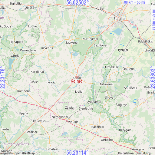
Kelmė GPS coordinates[2]
55° 37' 48.324" North, 22° 56' 5.64" East
| Map corner | latitude | longitude |
|---|---|---|
| Upper-left | 56.02502°, | 22.23178° |
| Center: | 55.63009°, | 22.9349° |
| Lower-right: | 55.23114°, | 23.63803° |
| Map W x H: | 88.3×88.3 km | = 54.9×54.9mi |
| max Lat: | 56.36149° ⇑29.1% North |
| Kelmė: | 55.63009° |
| min Lat: | ⇓70.9% South 54.01573° |
| min Long | Kelmė | max Long |
| 20.99651° | 22.9349° | 26.43984° |
| W 26.1%⇐ | ⇒73.9% E |
Elevation
Elevation of Kelmė is 131 m = 430 ft, and this is 40.3 m = 132 ft above average elevation for this country.
| Max E: |
204 m = 669 ft | 22.4% |
| Kelmė | 131 m 430 ft | |
| Avg. | 90.7 m = 298 ft | |
Min E: |
-1 m = -3 ft | 77.6% |
See also: Lithuania elevation on elevation.city.
Geographical zone
Kelmė is located in North temperate zone (between Tropic of Cancer and the Arctic Circle). Distance of this North polar circle is 1215.7 km =755.4 mi to North.| Distance of | km | miles | from Kelmė |
|---|---|---|---|
| North Pole | 3821.6 | 2374.6 | to North |
| Arctic Circle | 1215.7 | 755.4 | to North |
| Tropic Cancer | 3579.6 | 2224.3 | to South |
| Equator | 6185.5 | 3843.5 | to South |


Nearby cities:
15 places around Kelmė: (largest is in red/bold)
• Ariogala
53.3 km =33.1 mi,  140°
140°
• Būgai
31.6 km =19.6 mi,  220°
220°
• Gelgaudiškis
61.6 km =38.3 mi,  177°
177°
• Jurbarkas
62.6 km =38.9 mi,  189°
189°
• Kuršėnai
41.5 km =25.8 mi,  0°
0°
• Radviliskis
42.8 km =26.6 mi,  61°
61°
• Raseiniai
30.3 km =18.8 mi,  156°
156°
• Taurage
58.5 km =36.4 mi, 224°
• Telsiai
58.1 km =36.1 mi,  312°
312°
• Tytuvėnėliai
14.9 km =9.3 mi,  92°
92°
• Užventis
24.6 km =15.3 mi, 313°
• Varniai
37.5 km =23.3 mi,  289°
289°
• Šeduva
53.1 km =33 mi,  75°
75°
• Šiauliai
41.3 km =25.7 mi,  35°
35°
• Šilalė
49.6 km =30.8 mi,  251°
251°
Sources, notices
• [Note1] Compared only with cities in Lithuania existing in our database
• [Src1] Map data: © OpenStreetMap contributors (CC-BY-SA)
• [Src2] Other city data from geonames.org with taken over terms of usage.
• [Src3] Geographical zone / Annual Mean Temperature by Robert A. Rohde @ Wikipedia
