Vabalninkas geodata
Vabalninkas (Panevėžys) is a populated place; located in Lithuania in Europe/Vilnius (GMT+3) time zone. With population of 1,177 people, there are 117 cities with bigger population in this country. Compared to other cities in Lithuania, 86.6% of cities are located further ↓South; 68.7% of cities are located further ←West and 71.6% of cities have higher elevation than Vabalninkas. Note1


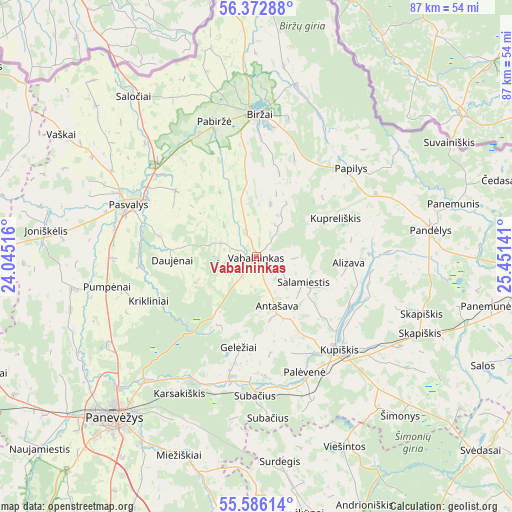
Vabalninkas GPS coordinates[2]
55° 58' 53.436" North, 24° 44' 53.808" East
| Map corner | latitude | longitude |
|---|---|---|
| Upper-left | 56.37288°, | 24.04516° |
| Center: | 55.98151°, | 24.74828° |
| Lower-right: | 55.58614°, | 25.45141° |
| Map W x H: | 87.5×87.5 km | = 54.4×54.4mi |
| max Lat: | 56.36149° ⇑13.4% North |
| Vabalninkas: | 55.98151° |
| min Lat: | ⇓86.6% South 54.01573° |
| min Long | Vabalninkas | max Long |
| 20.99651° | 24.74828° | 26.43984° |
| W 68.7%⇐ | ⇒31.3% E |
Elevation
Elevation of Vabalninkas is 64 m = 210 ft, and this is 26.7 m = 88 ft below average elevation for this country.
| Max E: |
204 m = 669 ft | 71.6% |
| Avg. | 90.7 m = 298 ft | |
| Vabalninkas | 64 m = 210 ft | |
Min E: |
-1 m = -3 ft | 28.4% |
See also: Lithuania elevation on elevation.city.
Geographical zone
Vabalninkas is located in North temperate zone (between Tropic of Cancer and the Arctic Circle). Distance of this North polar circle is 1176.6 km =731.1 mi to North.| Distance of | km | miles | from Vabalninkas |
|---|---|---|---|
| North Pole | 3782.5 | 2350.3 | to North |
| Arctic Circle | 1176.6 | 731.1 | to North |
| Tropic Cancer | 3618.6 | 2248.5 | to South |
| Equator | 6224.6 | 3867.8 | to South |


Nearby cities:
15 places around Vabalninkas: (largest is in red/bold)
• Anyksciai
55.3 km =34.4 mi,  156°
156°
• Birzai
24.3 km =15.1 mi,  0°
0°
• Juodupė
54.6 km =33.9 mi,  77°
77°
• Kavarskas
61.9 km =38.5 mi,  169°
169°
• Kupiskis
21.3 km =13.2 mi,  137°
137°
• Linkuva
49.7 km =30.9 mi,  283°
283°
• Naujamiestis
49.5 km =30.8 mi,  228°
228°
• Obeliai
25.4 km =15.8 mi,  93°
93°
• Pakruojis
55.6 km =34.5 mi,  269°
269°
• Pandėlys
30.1 km =18.7 mi, 80°
• Panevėžys
37.1 km =23.1 mi,  222°
222°
• Pasvalys
23.1 km =14.4 mi,  292°
292°
• Ramygala
59.1 km =36.7 mi,  208°
208°
• Rokiškis
52.7 km =32.7 mi, 92°
• Šeduva
67.1 km =41.7 mi,  247°
247°
Sources, notices
• [Note1] Compared only with cities in Lithuania existing in our database
• [Src1] Map data: © OpenStreetMap contributors (CC-BY-SA)
• [Src2] Other city data from geonames.org with taken over terms of usage.
• [Src3] Geographical zone / Annual Mean Temperature by Robert A. Rohde @ Wikipedia
