Pandėlys geodata
Pandėlys is a populated place; located in Lithuania in Europe/Vilnius (GMT+3) time zone. With population of 973 people, there are 122 cities with bigger population in this country. Compared to other cities in Lithuania, 88.8% of cities are located further ↓South; 83.6% of cities are located further ←West and 53% of cities have lower elevation than Pandėlys. Note1


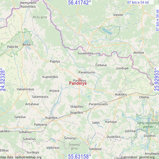
Pandėlys GPS coordinates[2]
56° 1' 35.4" North, 25° 13' 35.04" East
| Map corner | latitude | longitude |
|---|---|---|
| Upper-left | 56.41742°, | 24.52328° |
| Center: | 56.0265°, | 25.2264° |
| Lower-right: | 55.63158°, | 25.92953° |
| Map W x H: | 87.4×87.4 km | = 54.3×54.3mi |
| max Lat: | 56.36149° ⇑11.2% North |
| Pandėlys: | 56.0265° |
| min Lat: | ⇓88.8% South 54.01573° |
| min Long | Pandėlys | max Long |
| 20.99651° | 25.2264° | 26.43984° |
| W 83.6%⇐ | ⇒16.4% E |
Elevation
Elevation of Pandėlys is 90 m = 295 ft, and this is 0.7 m = 2 ft below average elevation for this country.
| Max E: |
204 m = 669 ft | 47% |
| Avg. | 90.7 m = 298 ft | |
| Pandėlys | 90 m = 295 ft | |
Min E: |
-1 m = -3 ft | 53% |
See also: Lithuania elevation on elevation.city.
Geographical zone
Pandėlys is located in North temperate zone (between Tropic of Cancer and the Arctic Circle). Distance of this North polar circle is 1171.6 km =728 mi to North.| Distance of | km | miles | from Pandėlys |
|---|---|---|---|
| North Pole | 3777.5 | 2347.2 | to North |
| Arctic Circle | 1171.6 | 728 | to North |
| Tropic Cancer | 3623.6 | 2251.6 | to South |
| Equator | 6229.6 | 3870.9 | to South |


Nearby cities:
15 places around Pandėlys: (largest is in red/bold)
• Anyksciai
56.2 km =34.9 mi,  187°
187°
• Birzai
35.3 km =21.9 mi,  303°
303°
• Dusetos
49.6 km =30.8 mi,  128°
128°
• Juodupė
24.6 km =15.3 mi,  74°
74°
• Kavarskas
68.5 km =42.6 mi,  195°
195°
• Kupiskis
25.8 km =16 mi,  216°
216°
• Linkuva
78.2 km =48.6 mi,  274°
274°
• Naujamiestis
76.9 km =47.8 mi,  240°
240°
• Obeliai
7.7 km =4.8 mi,  214°
214°
• Panevėžys
63.6 km =39.5 mi, 239°
• Pasvalys
51.2 km =31.8 mi, 274°
• Rokiškis
24.1 km =15 mi,  108°
108°
• Utena
63.3 km =39.3 mi,  158°
158°
• Vabalninkas
30.1 km =18.7 mi,  260°
260°
• Zarasai
71.8 km =44.6 mi,  117°
117°
Sources, notices
• [Note1] Compared only with cities in Lithuania existing in our database
• [Src1] Map data: © OpenStreetMap contributors (CC-BY-SA)
• [Src2] Other city data from geonames.org with taken over terms of usage.
• [Src3] Geographical zone / Annual Mean Temperature by Robert A. Rohde @ Wikipedia
