Juodupė geodata
Juodupė (Panevėžys) is a populated place; located in Lithuania in Europe/Vilnius (GMT+3) time zone. With population of 1,989 people, there are 94 cities with bigger population in this country. Compared to other cities in Lithuania, 92.5% of cities are located further ↓South; 93.3% of cities are located further ←West and 64.2% of cities have lower elevation than Juodupė. Note1


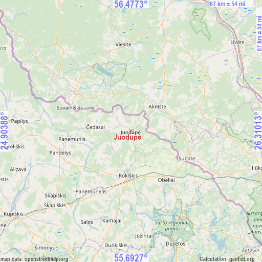
Juodupė GPS coordinates[2]
56° 5' 13.2" North, 25° 36' 25.2" East
| Map corner | latitude | longitude |
|---|---|---|
| Upper-left | 56.4773°, | 24.90388° |
| Center: | 56.087°, | 25.607° |
| Lower-right: | 55.6927°, | 26.31013° |
| Map W x H: | 87.2×87.2 km | = 54.2×54.2mi |
| max Lat: | 56.36149° ⇑7.5% North |
| Juodupė: | 56.087° |
| min Lat: | ⇓92.5% South 54.01573° |
| min Long | Juodupė | max Long |
| 20.99651° | 25.607° | 26.43984° |
| W 93.3%⇐ | ⇒6.7% E |
Elevation
Elevation of Juodupė is 107 m = 351 ft, and this is 16.3 m = 53 ft above average elevation for this country.
| Max E: |
204 m = 669 ft | 35.8% |
| Juodupė | 107 m 351 ft | |
| Avg. | 90.7 m = 298 ft | |
Min E: |
-1 m = -3 ft | 64.2% |
See also: Lithuania elevation on elevation.city.
Geographical zone
Juodupė is located in North temperate zone (between Tropic of Cancer and the Arctic Circle). Distance of this North polar circle is 1164.9 km =723.8 mi to North.| Distance of | km | miles | from Juodupė |
|---|---|---|---|
| North Pole | 3770.8 | 2343.1 | to North |
| Arctic Circle | 1164.9 | 723.8 | to North |
| Tropic Cancer | 3630.4 | 2255.8 | to South |
| Equator | 6236.3 | 3875.1 | to South |


Nearby cities:
15 places around Juodupė: (largest is in red/bold)
• Anyksciai
69.9 km =43.4 mi,  206°
206°
• Birzai
54.6 km =33.9 mi,  283°
283°
• Dusetos
40.7 km =25.3 mi,  158°
158°
• Dūkštas
77.1 km =47.9 mi,  144°
144°
• Kavarskas
84.1 km =52.3 mi, 210°
• Kupiskis
47.7 km =29.6 mi,  234°
234°
• Obeliai
30.9 km =19.2 mi,  244°
244°
• Pandėlys
24.6 km =15.3 mi,  254°
254°
• Panevėžys
87.7 km =54.5 mi, 243°
• Pasvalys
74.7 km =46.4 mi,  267°
267°
• Rokiškis
14.3 km =8.9 mi,  183°
183°
• Utena
65.5 km =40.7 mi, 180°
• Vabalninkas
54.6 km =33.9 mi,  257°
257°
• Visaginas
75.3 km =46.8 mi, 136°
• Zarasai
56.3 km =35 mi,  134°
134°
Sources, notices
• [Note1] Compared only with cities in Lithuania existing in our database
• [Src1] Map data: © OpenStreetMap contributors (CC-BY-SA)
• [Src2] Other city data from geonames.org with taken over terms of usage.
• [Src3] Geographical zone / Annual Mean Temperature by Robert A. Rohde @ Wikipedia
