Ampanihy geodata
Ampanihy (Atsimo-Andrefana) is a seat of a second-order administrative division; located in Madagascar in Indian/Antananarivo (GMT+3) time zone. With population of 25,686 people, there are 46 cities with bigger population in this country. Compared to other cities in Madagascar, 94.3% of cities are located further ↑North; 91.1% of cities are located further →East and 50.4% of cities have higher elevation than Ampanihy. Note1


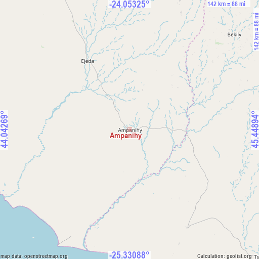
Ampanihy GPS coordinates[2]
24° 41' 37.32" South, 44° 44' 44.916" East
| Map corner | latitude | longitude |
|---|---|---|
| Upper-left | -24.05325°, | 44.04269° |
| Center: | -24.6937°, | 44.74581° |
| Lower-right: | -25.33088°, | 45.44894° |
| Map W x H: | 142.1×142.1 km | = 88.3×88.3mi |
| max Lat: | -12.31732° ⇑94.3% North |
| Ampanihy: | -24.6937° |
| min Lat: | ⇓5.7% South -25.3° |
| min Long | Ampanihy | max Long |
| 43.65° | 44.74581° | 50.27876° |
| W 8.9%⇐ | ⇒91.1% E |
Elevation
Elevation of Ampanihy is 236 m = 774 ft, and this is 321.4 m = 1054 ft below average elevation for this country.
| Max E: |
1763 m = 5784 ft | 50.4% |
| Avg. | 557.4 m = 1829 ft | |
| Ampanihy | 236 m = 774 ft | |
Min E: |
1 m = 3 ft | 49.6% |
See also: Madagascar elevation on elevation.city.
Geographical zone
Ampanihy is located in South temperate zone (between Tropic of Capricorn and the Antarctic Circle). Distance of this Southern Tropic circle is 139.8 km =86.9 mi to North.| Distance of | km | miles | from Ampanihy |
|---|---|---|---|
| Equator | 2745.7 | 1706.1 | to North |
| Tropic Capricorn | 139.8 | 86.9 | to North |
| Antarctic Circle | 4655.5 | 2892.8 | to South |
| South Pole | 7261.4 | 4512 | to South |


Nearby cities:
15 places around Ampanihy: (largest is in red/bold)
• Ambalasoa
216.8 km =134.7 mi,  36°
36°
• Amboasary
128.2 km =79.7 mi,  71°
71°
• Amboasary
169.5 km =105.3 mi,  102°
102°
• Ambovombe
145.6 km =90.5 mi,  111°
111°
• Anakao
159.4 km =99 mi,  315°
315°
• Antanimena
143.1 km =88.9 mi,  332°
332°
• Behompy
184.5 km =114.6 mi, 330°
• Beloha
60.9 km =37.8 mi,  149°
149°
• Beteza
46.3 km =28.8 mi,  54°
54°
• Betioky
114.4 km =71.1 mi,  341°
341°
• Kopoky
72.6 km =45.1 mi,  140°
140°
• Sakaraha
200.6 km =124.6 mi,  353°
353°
• Toliara
185.3 km =115.1 mi, 323°
• Tranovaho
71 km =44.1 mi,  161°
161°
• Tsiombe
100.3 km =62.3 mi,  132°
132°
Sources, notices
• [Note1] Compared only with cities in Madagascar existing in our database
• [Src1] Map data: © OpenStreetMap contributors (CC-BY-SA)
• [Src2] Other city data from geonames.org with taken over terms of usage.
• [Src3] Geographical zone / Annual Mean Temperature by Robert A. Rohde @ Wikipedia
