Ambalasoa geodata
Ambalasoa (Anosy) is a populated place; located in Madagascar in Indian/Antananarivo (GMT+3) time zone. With population of 4,000 people, there are 112 cities with bigger population in this country. Compared to other cities in Madagascar, 86.2% of cities are located further ↑North; 82.1% of cities are located further →East and 67.5% of cities have lower elevation than Ambalasoa. Note1
Administrative division(s):
- Level 1: Anosy
- Level 2: Betroka District
- Level 3: Ambalasoa
- Level 4: Fenoarivo


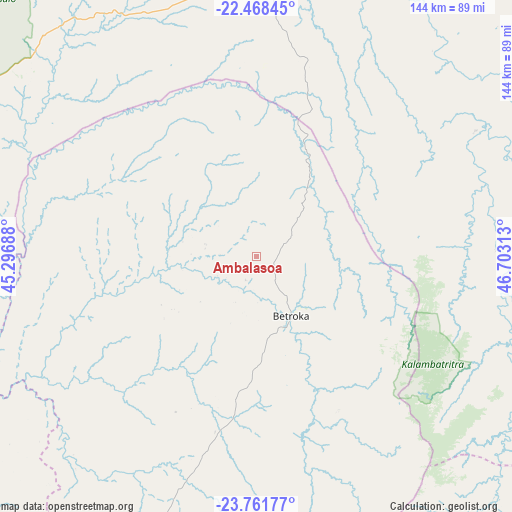
Ambalasoa GPS coordinates[2]
23° 7' 0.012" South, 46° 0' 0" East
| Map corner | latitude | longitude |
|---|---|---|
| Upper-left | -22.46845°, | 45.29688° |
| Center: | -23.11667°, | 46° |
| Lower-right: | -23.76177°, | 46.70313° |
| Map W x H: | 143.8×143.8 km | = 89.4×89.4mi |
| max Lat: | -12.31732° ⇑86.2% North |
| Ambalasoa: | -23.11667° |
| min Lat: | ⇓13.8% South -25.3° |
| min Long | Ambalasoa | max Long |
| 43.65° | 46° | 50.27876° |
| W 17.9%⇐ | ⇒82.1% E |
Elevation
Elevation of Ambalasoa is 883 m = 2897 ft, and this is 325.6 m = 1068 ft above average elevation for this country.
| Max E: |
1763 m = 5784 ft | 32.5% |
| Ambalasoa | 883 m 2897 ft | |
| Avg. | 557.4 m = 1829 ft | |
Min E: |
1 m = 3 ft | 67.5% |
See also: Madagascar elevation on elevation.city.
Geographical zone
Ambalasoa is located in South Torrid zone (between Equator and Tropic of Capricorn). Distance of this Southern Tropic circle is 35.6 km =22.1 mi to South.| Distance of | km | miles | from Ambalasoa |
|---|---|---|---|
| Equator | 2570.3 | 1597.1 | to North |
| Tropic Capricorn | 35.6 | 22.1 | to South |
| Antarctic Circle | 4830.8 | 3001.7 | to South |
| South Pole | 7436.7 | 4620.9 | to South |


Nearby cities:
15 places around Ambalasoa: (largest is in red/bold)
• Ambalavao
171.9 km =106.8 mi,  33°
33°
• Amboasary
135.4 km =84.1 mi,  182°
182°
• Anandravy
141.9 km =88.2 mi,  80°
80°
• Ankazoabo
178.1 km =110.7 mi,  301°
301°
• Beroroha
182.6 km =113.5 mi,  332°
332°
• Beteza
173.4 km =107.7 mi,  211°
211°
• Betioky
178.3 km =110.8 mi,  247°
247°
• Farafangana
189.8 km =117.9 mi, 80°
• Ihosy
80.4 km =50 mi,  9°
9°
• Manato
171.7 km =106.7 mi,  62°
62°
• Ranohira
93.5 km =58.1 mi,  318°
318°
• Sakaraha
152 km =94.4 mi,  279°
279°
• Vangaindrano
165.5 km =102.8 mi,  99°
99°
• Vohipaho
160.5 km =99.7 mi,  107°
107°
• Vondrozo
135.5 km =84.2 mi, 75°
Sources, notices
• [Note1] Compared only with cities in Madagascar existing in our database
• [Src1] Map data: © OpenStreetMap contributors (CC-BY-SA)
• [Src2] Other city data from geonames.org with taken over terms of usage.
• [Src3] Geographical zone / Annual Mean Temperature by Robert A. Rohde @ Wikipedia
