Anakao geodata
Anakao (Atsimo-Andrefana) is a populated place; located in Madagascar in Indian/Antananarivo (GMT+3) time zone. With population of 3,000 people, there are 116 cities with bigger population in this country. Compared to other cities in Madagascar, 91.1% of cities are located further ↑North; 100% of cities are located further →East and 99.2% of cities have higher elevation than Anakao. Note1
Administrative division(s):
- Level 1: Atsimo-Andrefana
- Level 2: Toliara II District
- Level 3: Anakao
- Level 4: Anakao Haut


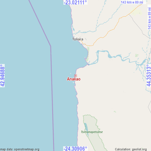
Anakao GPS coordinates[2]
23° 40' 0.012" South, 43° 39' 0" East
| Map corner | latitude | longitude |
|---|---|---|
| Upper-left | -23.02111°, | 42.94688° |
| Center: | -23.66667°, | 43.65° |
| Lower-right: | -24.30906°, | 44.35313° |
| Map W x H: | 143.2×143.2 km | = 89×89mi |
| max Lat: | -12.31732° ⇑91.1% North |
| Anakao: | -23.66667° |
| min Lat: | ⇓8.9% South -25.3° |
| min Long | Anakao | max Long |
| 43.65° | 43.65° | 50.27876° |
| W 0%⇐ | ⇒100% E |
Elevation
Elevation of Anakao is 2 m = 7 ft, and this is 555.4 m = 1822 ft below average elevation for this country.
| Max E: |
1763 m = 5784 ft | 99.2% |
| Avg. | 557.4 m = 1829 ft | |
| Anakao | 2 m = 7 ft | |
Min E: |
1 m = 3 ft | 0.8% |
See also: Madagascar elevation on elevation.city.
Geographical zone
Anakao is located in South temperate zone (between Tropic of Capricorn and the Antarctic Circle). Distance of this Southern Tropic circle is 25.6 km =15.9 mi to North.| Distance of | km | miles | from Anakao |
|---|---|---|---|
| Equator | 2631.5 | 1635.1 | to North |
| Tropic Capricorn | 25.6 | 15.9 | to North |
| Antarctic Circle | 4769.7 | 2963.8 | to South |
| South Pole | 7375.6 | 4583 | to South |


Nearby cities:
15 places around Anakao: (largest is in red/bold)
• Ambalasoa
247.5 km =153.8 mi,  75°
75°
• Amboasary
245.1 km =152.3 mi,  107°
107°
• Ampanihy
159.4 km =99 mi,  135°
135°
• Ankazoabo
177.6 km =110.4 mi,  29°
29°
• Antanimena
47.6 km =29.6 mi,  74°
74°
• Behompy
50.6 km =31.4 mi,  23°
23°
• Beloha
218.9 km =136 mi, 139°
• Beteza
172.5 km =107.2 mi,  120°
120°
• Betioky
74.6 km =46.4 mi,  94°
94°
• Kopoky
231.7 km =144 mi, 137°
• Manja
258 km =160.3 mi, 15°
• Ranohira
222.2 km =138.1 mi,  53°
53°
• Sakaraha
124.1 km =77.1 mi, 46°
• Toliara
35.3 km =21.9 mi,  2°
2°
• Tranovaho
225.2 km =139.9 mi, 143°
Sources, notices
• [Note1] Compared only with cities in Madagascar existing in our database
• [Src1] Map data: © OpenStreetMap contributors (CC-BY-SA)
• [Src2] Other city data from geonames.org with taken over terms of usage.
• [Src3] Geographical zone / Annual Mean Temperature by Robert A. Rohde @ Wikipedia
