Sakaraha geodata
Sakaraha (Atsimo-Andrefana) is a populated place; located in Madagascar in Indian/Antananarivo (GMT+3) time zone. With population of 21,826 people, there are 58 cities with bigger population in this country. Compared to other cities in Madagascar, 85.4% of cities are located further ↑North; 92.7% of cities are located further →East and 59.3% of cities have lower elevation than Sakaraha. Note1
Administrative division(s):
- Level 1: Atsimo-Andrefana
- Level 2: Sakaraha District
- Level 3: Sakaraha
- Level 4: Andranovory Tandroy


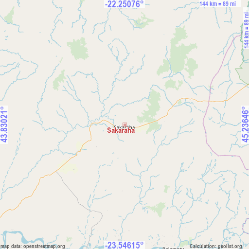
Sakaraha GPS coordinates[2]
22° 54' 0" South, 44° 31' 59.988" East
| Map corner | latitude | longitude |
|---|---|---|
| Upper-left | -22.25076°, | 43.83021° |
| Center: | -22.9°, | 44.53333° |
| Lower-right: | -23.54615°, | 45.23646° |
| Map W x H: | 144×144 km | = 89.5×89.5mi |
| max Lat: | -12.31732° ⇑85.4% North |
| Sakaraha: | -22.9° |
| min Lat: | ⇓14.6% South -25.3° |
| min Long | Sakaraha | max Long |
| 43.65° | 44.53333° | 50.27876° |
| W 7.3%⇐ | ⇒92.7% E |
Elevation
Elevation of Sakaraha is 480 m = 1575 ft, and this is 77.4 m = 254 ft below average elevation for this country.
| Max E: |
1763 m = 5784 ft | 40.7% |
| Avg. | 557.4 m = 1829 ft | |
| Sakaraha | 480 m = 1575 ft | |
Min E: |
1 m = 3 ft | 59.3% |
See also: Madagascar elevation on elevation.city.
Geographical zone
Sakaraha is located in South Torrid zone (between Equator and Tropic of Capricorn). Distance of this Southern Tropic circle is 59.7 km =37.1 mi to South.| Distance of | km | miles | from Sakaraha |
|---|---|---|---|
| Equator | 2546.2 | 1582.1 | to North |
| Tropic Capricorn | 59.7 | 37.1 | to South |
| Antarctic Circle | 4854.9 | 3016.7 | to South |
| South Pole | 7460.8 | 4635.9 | to South |


Nearby cities:
15 places around Sakaraha: (largest is in red/bold)
• Ambalasoa
152 km =94.4 mi,  99°
99°
• Amboasary
215 km =133.6 mi,  137°
137°
• Ampanihy
200.6 km =124.6 mi,  173°
173°
• Anakao
124.1 km =77.1 mi,  226°
226°
• Ankazoabo
68.6 km =42.6 mi,  358°
358°
• Antanimena
84.8 km =52.7 mi,  211°
211°
• Behompy
80 km =49.7 mi,  240°
240°
• Beloha
257.4 km =159.9 mi, 168°
• Beroroha
151.8 km =94.3 mi,  25°
25°
• Beteza
182.3 km =113.3 mi,  160°
160°
• Betioky
92.6 km =57.5 mi,  189°
189°
• Ihosy
172.5 km =107.2 mi,  71°
71°
• Manja
164.4 km =102.2 mi,  352°
352°
• Ranohira
100.3 km =62.3 mi,  62°
62°
• Toliara
101.8 km =63.3 mi, 240°
Sources, notices
• [Note1] Compared only with cities in Madagascar existing in our database
• [Src1] Map data: © OpenStreetMap contributors (CC-BY-SA)
• [Src2] Other city data from geonames.org with taken over terms of usage.
• [Src3] Geographical zone / Annual Mean Temperature by Robert A. Rohde @ Wikipedia
