Nyaungdon geodata
Nyaungdon (Ayeyarwady) is a populated place; located in Myanmar in Asia/Yangon (GMT+6.5) time zone. With population of 40,092 people, there are 59 cities with bigger population in this country. Compared to other cities in Myanmar, 59.5% of cities are located further ↑North; 70.3% of cities are located further →East and 91.9% of cities have higher elevation than Nyaungdon. Note1


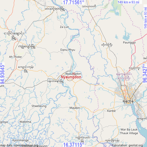
Nyaungdon GPS coordinates[2]
17° 2' 40.524" North, 95° 38' 22.452" East
| Map corner | latitude | longitude |
|---|---|---|
| Upper-left | 17.71561°, | 94.93645° |
| Center: | 17.04459°, | 95.63957° |
| Lower-right: | 16.37115°, | 96.3427° |
| Map W x H: | 149.5×149.5 km | = 92.9×92.9mi |
| max Lat: | 25.38327° ⇑59.5% North |
| Nyaungdon: | 17.04459° |
| min Lat: | ⇓40.5% South 9.98238° |
| min Long | Nyaungdon | max Long |
| 92.89835° | 95.63957° | 99.88083° |
| W 29.7%⇐ | ⇒70.3% E |
Elevation
Elevation of Nyaungdon is 11 m = 36 ft, and this is 177.9 m = 584 ft below average elevation for this country.
| Max E: |
1768 m = 5801 ft | 91.9% |
| Avg. | 188.9 m = 620 ft | |
| Nyaungdon | 11 m = 36 ft | |
Min E: |
5 m = 16 ft | 8.1% |
See also: Nyaungdon elevation on elevation.city.
Geographical zone
Nyaungdon is located in North Torrid zone (between Equator and Tropic of Cancer). Distance of this Northern Tropic circle is 710.7 km =441.6 mi to North.| Distance of | km | miles | from Nyaungdon |
|---|---|---|---|
| North Pole | 8111.9 | 5040.5 | to North |
| Arctic Circle | 5506 | 3421.3 | to North |
| Tropic Cancer | 710.7 | 441.6 | to North |
| Equator | 1895.2 | 1177.6 | to South |


Nearby cities:
15 places around Nyaungdon: (largest is in red/bold)
• Bago
95.1 km =59.1 mi,  70°
70°
• Bogale
87.3 km =54.2 mi,  197°
197°
• Hinthada
70 km =43.5 mi,  343°
343°
• Kanbe
53.8 km =33.4 mi,  134°
134°
• Kayan
99.1 km =61.6 mi,  98°
98°
• Kyaiklat
67.3 km =41.8 mi,  172°
172°
• Letpandan
83.3 km =51.8 mi,  8°
8°
• Maubin
34.9 km =21.7 mi,  177°
177°
• Mawlamyinegyunn
84.3 km =52.4 mi,  208°
208°
• Pyapon
84.5 km =52.5 mi, 177°
• Syriam
71.3 km =44.3 mi,  115°
115°
• Tharyarwady
69.6 km =43.2 mi, 13°
• Twante
48.2 km =30 mi,  140°
140°
• Wakema
69.1 km =42.9 mi,  224°
224°
• Yangon
61.1 km =38 mi, 115°
Sources, notices
• [Note1] Compared only with cities in Myanmar existing in our database
• [Src1] Map data: © OpenStreetMap contributors (CC-BY-SA)
• [Src2] Other city data from geonames.org with taken over terms of usage.
• [Src3] Geographical zone / Annual Mean Temperature by Robert A. Rohde @ Wikipedia
