Wakema geodata
Wakema (Ayeyarwady) is a populated place; located in Myanmar in Asia/Yangon (GMT+6.5) time zone. With population of 42,705 people, there are 55 cities with bigger population in this country. Compared to other cities in Myanmar, 75.7% of cities are located further ↑North; 83.8% of cities are located further →East and 91.9% of cities have higher elevation than Wakema. Note1


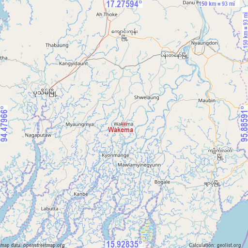
Wakema GPS coordinates[2]
16° 36' 11.988" North, 95° 10' 58.008" East
| Map corner | latitude | longitude |
|---|---|---|
| Upper-left | 17.27594°, | 94.47966° |
| Center: | 16.60333°, | 95.18278° |
| Lower-right: | 15.92835°, | 95.88591° |
| Map W x H: | 149.8×149.8 km | = 93.1×93.1mi |
| max Lat: | 25.38327° ⇑75.7% North |
| Wakema: | 16.60333° |
| min Lat: | ⇓24.3% South 9.98238° |
| min Long | Wakema | max Long |
| 92.89835° | 95.18278° | 99.88083° |
| W 16.2%⇐ | ⇒83.8% E |
Elevation
Elevation of Wakema is 11 m = 36 ft, and this is 177.9 m = 584 ft below average elevation for this country.
| Max E: |
1768 m = 5801 ft | 91.9% |
| Avg. | 188.9 m = 620 ft | |
| Wakema | 11 m = 36 ft | |
Min E: |
5 m = 16 ft | 8.1% |
See also: Wakema elevation on elevation.city.
Geographical zone
Wakema is located in North Torrid zone (between Equator and Tropic of Cancer). Distance of this Northern Tropic circle is 759.8 km =472.1 mi to North.| Distance of | km | miles | from Wakema |
|---|---|---|---|
| North Pole | 8160.9 | 5070.9 | to North |
| Arctic Circle | 5555.1 | 3451.8 | to North |
| Tropic Cancer | 759.8 | 472.1 | to North |
| Equator | 1846.1 | 1147.1 | to South |


Nearby cities:
15 places around Wakema: (largest is in red/bold)
• Bogale
41.3 km =25.7 mi,  146°
146°
• Hinthada
119.9 km =74.5 mi,  14°
14°
• Kanbe
88 km =54.7 mi,  82°
82°
• Kyaiklat
60.3 km =37.5 mi,  106°
106°
• Letpandan
144.7 km =89.9 mi,  24°
24°
• Maubin
52.2 km =32.4 mi,  74°
74°
• Mawlamyinegyunn
26.6 km =16.5 mi,  160°
160°
• Nyaungdon
69.1 km =42.9 mi,  44°
44°
• Pathein
51.8 km =32.2 mi,  292°
292°
• Pyapon
63.6 km =39.5 mi,  123°
123°
• Syriam
114.6 km =71.2 mi, 80°
• Tharyarwady
133.4 km =82.9 mi,  28°
28°
• Thongwa
144 km =89.5 mi, 83°
• Twante
80.3 km =49.9 mi, 81°
• Yangon
106.1 km =65.9 mi, 77°
Sources, notices
• [Note1] Compared only with cities in Myanmar existing in our database
• [Src1] Map data: © OpenStreetMap contributors (CC-BY-SA)
• [Src2] Other city data from geonames.org with taken over terms of usage.
• [Src3] Geographical zone / Annual Mean Temperature by Robert A. Rohde @ Wikipedia
