Syriam geodata
Syriam (Rangoon) is a populated place; located in Myanmar in Asia/Yangon (GMT+6.5) time zone. With population of 69,448 people, there are 33 cities with bigger population in this country. Compared to other cities in Myanmar, 67.6% of cities are located further ↑North; 52.7% of cities are located further ←West and 60.8% of cities have higher elevation than Syriam. Note1


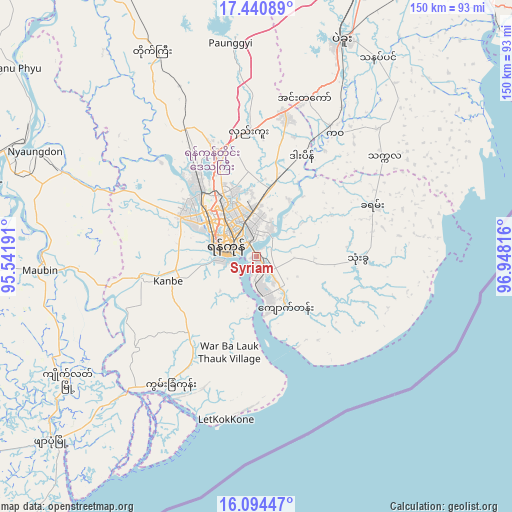
Syriam GPS coordinates[2]
16° 46' 7.932" North, 96° 14' 42.108" East
| Map corner | latitude | longitude |
|---|---|---|
| Upper-left | 17.44089°, | 95.54191° |
| Center: | 16.76887°, | 96.24503° |
| Lower-right: | 16.09447°, | 96.94816° |
| Map W x H: | 149.7×149.7 km | = 93×93mi |
| max Lat: | 25.38327° ⇑67.6% North |
| Syriam: | 16.76887° |
| min Lat: | ⇓32.4% South 9.98238° |
| min Long | Syriam | max Long |
| 92.89835° | 96.24503° | 99.88083° |
| W 52.7%⇐ | ⇒47.3% E |
Elevation
Elevation of Syriam is 24 m = 79 ft, and this is 164.9 m = 541 ft below average elevation for this country.
| Max E: |
1768 m = 5801 ft | 60.8% |
| Avg. | 188.9 m = 620 ft | |
| Syriam | 24 m = 79 ft | |
Min E: |
5 m = 16 ft | 39.2% |
See also: Syriam elevation on elevation.city.
Geographical zone
Syriam is located in North Torrid zone (between Equator and Tropic of Cancer). Distance of this Northern Tropic circle is 741.4 km =460.7 mi to North.| Distance of | km | miles | from Syriam |
|---|---|---|---|
| North Pole | 8142.5 | 5059.5 | to North |
| Arctic Circle | 5536.7 | 3440.3 | to North |
| Tropic Cancer | 741.4 | 460.7 | to North |
| Equator | 1864.5 | 1158.5 | to South |


Nearby cities:
15 places around Syriam: (largest is in red/bold)
• Bago
67.8 km =42.1 mi,  21°
21°
• Bogale
104.6 km =65 mi,  239°
239°
• Kanbe
26.8 km =16.7 mi,  255°
255°
• Kayan
37 km =23 mi,  65°
65°
• Kyaiklat
66.2 km =41.1 mi, 237°
• Kyaikto
101.2 km =62.9 mi,  53°
53°
• Maubin
63 km =39.1 mi,  266°
266°
• Mawlamyinegyunn
113.2 km =70.3 mi,  247°
247°
• Nyaungdon
71.3 km =44.3 mi,  295°
295°
• Pyapon
80.8 km =50.2 mi,  228°
228°
• Thanatpin
67.9 km =42.2 mi,  31°
31°
• Tharyarwady
109.7 km =68.2 mi,  333°
333°
• Thongwa
29.8 km =18.5 mi,  91°
91°
• Twante
34.3 km =21.3 mi, 259°
• Yangon
10.3 km =6.4 mi,  293°
293°
Sources, notices
• [Note1] Compared only with cities in Myanmar existing in our database
• [Src1] Map data: © OpenStreetMap contributors (CC-BY-SA)
• [Src2] Other city data from geonames.org with taken over terms of usage.
• [Src3] Geographical zone / Annual Mean Temperature by Robert A. Rohde @ Wikipedia
