Tharyarwady geodata
Tharyarwady (Bago) is a populated place; located in Myanmar in Asia/Yangon (GMT+6.5) time zone. With population of 54,386 people, there are 41 cities with bigger population in this country. Compared to other cities in Myanmar, 52.7% of cities are located further ↑North; 62.2% of cities are located further →East and 78.4% of cities have higher elevation than Tharyarwady. Note1


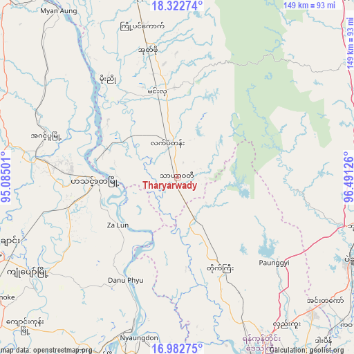
Tharyarwady GPS coordinates[2]
17° 39' 14.364" North, 95° 47' 17.268" East
| Map corner | latitude | longitude |
|---|---|---|
| Upper-left | 18.32274°, | 95.08501° |
| Center: | 17.65399°, | 95.78813° |
| Lower-right: | 16.98275°, | 96.49126° |
| Map W x H: | 149×149 km | = 92.6×92.6mi |
| max Lat: | 25.38327° ⇑52.7% North |
| Tharyarwady: | 17.65399° |
| min Lat: | ⇓47.3% South 9.98238° |
| min Long | Tharyarwady | max Long |
| 92.89835° | 95.78813° | 99.88083° |
| W 37.8%⇐ | ⇒62.2% E |
Elevation
Elevation of Tharyarwady is 17 m = 56 ft, and this is 171.9 m = 564 ft below average elevation for this country.
| Max E: |
1768 m = 5801 ft | 78.4% |
| Avg. | 188.9 m = 620 ft | |
| Tharyarwady | 17 m = 56 ft | |
Min E: |
5 m = 16 ft | 21.6% |
See also: Tharyarwady elevation on elevation.city.
Geographical zone
Tharyarwady is located in North Torrid zone (between Equator and Tropic of Cancer). Distance of this Northern Tropic circle is 643 km =399.5 mi to North.| Distance of | km | miles | from Tharyarwady |
|---|---|---|---|
| North Pole | 8044.1 | 4998.4 | to North |
| Arctic Circle | 5438.2 | 3379.1 | to North |
| Tropic Cancer | 643 | 399.5 | to North |
| Equator | 1962.9 | 1219.7 | to South |


Nearby cities:
15 places around Tharyarwady: (largest is in red/bold)
• Bago
81.6 km =50.7 mi,  115°
115°
• Hinthada
35.1 km =21.8 mi,  269°
269°
• Kanbe
107.7 km =66.9 mi,  167°
167°
• Kayan
116.6 km =72.5 mi,  135°
135°
• Letpandan
15.3 km =9.5 mi,  344°
344°
• Maubin
103.6 km =64.4 mi,  187°
187°
• Myanaung
86 km =53.4 mi,  324°
324°
• Nyaungdon
69.6 km =43.2 mi, 193°
• Nyaunglebin
104.4 km =64.9 mi,  71°
71°
• Paungde
97.8 km =60.8 mi, 342°
• Pyu
114.8 km =71.3 mi,  36°
36°
• Syriam
109.7 km =68.2 mi,  153°
153°
• Thanatpin
92.7 km =57.6 mi, 115°
• Twante
106 km =65.9 mi, 171°
• Yangon
102.1 km =63.4 mi,  157°
157°
Sources, notices
• [Note1] Compared only with cities in Myanmar existing in our database
• [Src1] Map data: © OpenStreetMap contributors (CC-BY-SA)
• [Src2] Other city data from geonames.org with taken over terms of usage.
• [Src3] Geographical zone / Annual Mean Temperature by Robert A. Rohde @ Wikipedia
