Twante geodata
Twante (Rangoon) is a populated place; located in Myanmar in Asia/Yangon (GMT+6.5) time zone. With population of 46,516 people, there are 52 cities with bigger population in this country. Compared to other cities in Myanmar, 71.6% of cities are located further ↑North; 59.5% of cities are located further →East and 82.4% of cities have higher elevation than Twante. Note1


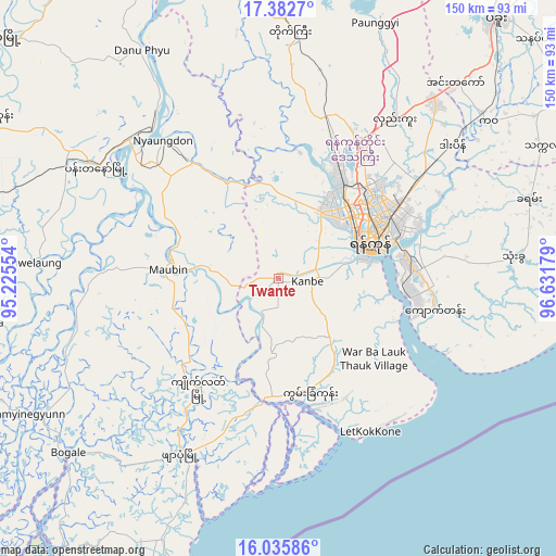
Twante GPS coordinates[2]
16° 42' 37.692" North, 95° 55' 43.176" East
| Map corner | latitude | longitude |
|---|---|---|
| Upper-left | 17.3827°, | 95.22554° |
| Center: | 16.71047°, | 95.92866° |
| Lower-right: | 16.03586°, | 96.63179° |
| Map W x H: | 149.8×149.8 km | = 93.1×93.1mi |
| max Lat: | 25.38327° ⇑71.6% North |
| Twante: | 16.71047° |
| min Lat: | ⇓28.4% South 9.98238° |
| min Long | Twante | max Long |
| 92.89835° | 95.92866° | 99.88083° |
| W 40.5%⇐ | ⇒59.5% E |
Elevation
Elevation of Twante is 14 m = 46 ft, and this is 174.9 m = 574 ft below average elevation for this country.
| Max E: |
1768 m = 5801 ft | 82.4% |
| Avg. | 188.9 m = 620 ft | |
| Twante | 14 m = 46 ft | |
Min E: |
5 m = 16 ft | 17.6% |
See also: Twante elevation on elevation.city.
Geographical zone
Twante is located in North Torrid zone (between Equator and Tropic of Cancer). Distance of this Northern Tropic circle is 747.9 km =464.7 mi to North.| Distance of | km | miles | from Twante |
|---|---|---|---|
| North Pole | 8149 | 5063.6 | to North |
| Arctic Circle | 5543.1 | 3444.3 | to North |
| Tropic Cancer | 747.9 | 464.7 | to North |
| Equator | 1858 | 1154.5 | to South |


Nearby cities:
15 places around Twante: (largest is in red/bold)
• Bago
91 km =56.5 mi,  40°
40°
• Bogale
73.1 km =45.4 mi,  230°
230°
• Kanbe
7.8 km =4.8 mi,  92°
92°
• Kayan
70.7 km =43.9 mi,  71°
71°
• Kyaiklat
36.7 km =22.8 mi,  216°
216°
• Maubin
29.3 km =18.2 mi,  274°
274°
• Mawlamyinegyunn
79.9 km =49.6 mi,  242°
242°
• Nyaungdon
48.2 km =30 mi,  320°
320°
• Pyapon
54.2 km =33.7 mi,  209°
209°
• Syriam
34.3 km =21.3 mi,  79°
79°
• Thanatpin
94.3 km =58.6 mi,  46°
46°
• Tharyarwady
106 km =65.9 mi,  351°
351°
• Thongwa
63.7 km =39.6 mi, 85°
• Wakema
80.3 km =49.9 mi,  261°
261°
• Yangon
26.4 km =16.4 mi, 66°
Sources, notices
• [Note1] Compared only with cities in Myanmar existing in our database
• [Src1] Map data: © OpenStreetMap contributors (CC-BY-SA)
• [Src2] Other city data from geonames.org with taken over terms of usage.
• [Src3] Geographical zone / Annual Mean Temperature by Robert A. Rohde @ Wikipedia
