Bago geodata
Bago is a seat of a first-order administrative division; located in Myanmar in Asia/Yangon (GMT+6.5) time zone. With population of 244,376 people, there are 5 cities with bigger population in this country. Compared to other cities in Myanmar, 55.4% of cities are located further ↑North; 58.1% of cities are located further ←West and 75.7% of cities have higher elevation than Bago. Note1


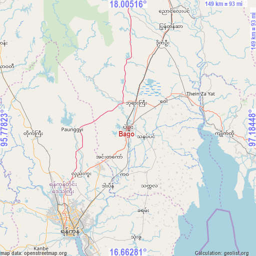
Bago GPS coordinates[2]
17° 20' 6.756" North, 96° 28' 52.86" East
| Map corner | latitude | longitude |
|---|---|---|
| Upper-left | 18.00516°, | 95.77823° |
| Center: | 17.33521°, | 96.48135° |
| Lower-right: | 16.66281°, | 97.18448° |
| Map W x H: | 149.3×149.3 km | = 92.8×92.8mi |
| max Lat: | 25.38327° ⇑55.4% North |
| Bago: | 17.33521° |
| min Lat: | ⇓44.6% South 9.98238° |
| min Long | Bago | max Long |
| 92.89835° | 96.48135° | 99.88083° |
| W 58.1%⇐ | ⇒41.9% E |
Elevation
Elevation of Bago is 18 m = 59 ft, and this is 170.9 m = 561 ft below average elevation for this country.
| Max E: |
1768 m = 5801 ft | 75.7% |
| Avg. | 188.9 m = 620 ft | |
| Bago | 18 m = 59 ft | |
Min E: |
5 m = 16 ft | 24.3% |
See also: Bago elevation on elevation.city.
Geographical zone
Bago is located in North Torrid zone (between Equator and Tropic of Cancer). Distance of this Northern Tropic circle is 678.4 km =421.5 mi to North.| Distance of | km | miles | from Bago |
|---|---|---|---|
| North Pole | 8079.6 | 5020.4 | to North |
| Arctic Circle | 5473.7 | 3401.2 | to North |
| Tropic Cancer | 678.4 | 421.5 | to North |
| Equator | 1927.5 | 1197.7 | to South |


Nearby cities:
15 places around Bago: (largest is in red/bold)
• Hinthada
114.1 km =70.9 mi,  287°
287°
• Kanbe
86.5 km =53.7 mi,  216°
216°
• Kayan
48.2 km =30 mi,  169°
169°
• Kyaikto
56.3 km =35 mi,  93°
93°
• Letpandan
92.3 km =57.4 mi,  302°
302°
• Maubin
110.6 km =68.7 mi,  232°
232°
• Nyaungdon
95.1 km =59.1 mi,  250°
250°
• Nyaunglebin
73.4 km =45.6 mi,  20°
20°
• Syriam
67.8 km =42.1 mi,  201°
201°
• Thanatpin
11.1 km =6.9 mi,  116°
116°
• Tharyarwady
81.6 km =50.7 mi, 295°
• Thaton
105.2 km =65.4 mi, 116°
• Thongwa
64.1 km =39.8 mi,  175°
175°
• Twante
91 km =56.5 mi, 220°
• Yangon
68.3 km =42.4 mi,  210°
210°
Sources, notices
• [Note1] Compared only with cities in Myanmar existing in our database
• [Src1] Map data: © OpenStreetMap contributors (CC-BY-SA)
• [Src2] Other city data from geonames.org with taken over terms of usage.
• [Src3] Geographical zone / Annual Mean Temperature by Robert A. Rohde @ Wikipedia
