Hinthada geodata
Hinthada (Ayeyarwady) is a populated place; located in Myanmar in Asia/Yangon (GMT+6.5) time zone. With population of 134,947 people, there are 15 cities with bigger population in this country. Compared to other cities in Myanmar, 54.1% of cities are located further ↑North; 74.3% of cities are located further →East and 81.1% of cities have higher elevation than Hinthada. Note1


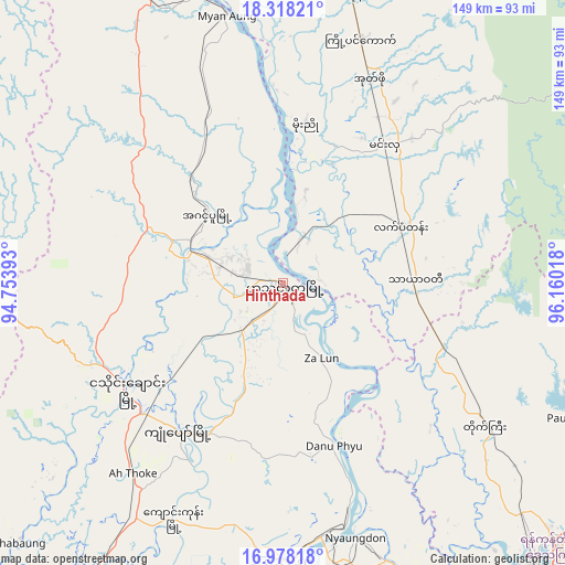
Hinthada GPS coordinates[2]
17° 38' 57.984" North, 95° 27' 25.38" East
| Map corner | latitude | longitude |
|---|---|---|
| Upper-left | 18.31821°, | 94.75393° |
| Center: | 17.64944°, | 95.45705° |
| Lower-right: | 16.97818°, | 96.16018° |
| Map W x H: | 149×149 km | = 92.6×92.6mi |
| max Lat: | 25.38327° ⇑54.1% North |
| Hinthada: | 17.64944° |
| min Lat: | ⇓45.9% South 9.98238° |
| min Long | Hinthada | max Long |
| 92.89835° | 95.45705° | 99.88083° |
| W 25.7%⇐ | ⇒74.3% E |
Elevation
Elevation of Hinthada is 15 m = 49 ft, and this is 173.9 m = 571 ft below average elevation for this country.
| Max E: |
1768 m = 5801 ft | 81.1% |
| Avg. | 188.9 m = 620 ft | |
| Hinthada | 15 m = 49 ft | |
Min E: |
5 m = 16 ft | 18.9% |
See also: Hinthada elevation on elevation.city.
Geographical zone
Hinthada is located in North Torrid zone (between Equator and Tropic of Cancer). Distance of this Northern Tropic circle is 643.5 km =399.9 mi to North.| Distance of | km | miles | from Hinthada |
|---|---|---|---|
| North Pole | 8044.6 | 4998.7 | to North |
| Arctic Circle | 5438.7 | 3379.5 | to North |
| Tropic Cancer | 643.5 | 399.9 | to North |
| Equator | 1962.4 | 1219.4 | to South |


Nearby cities:
15 places around Hinthada: (largest is in red/bold)
• Bago
114.1 km =70.9 mi,  107°
107°
• Kanbe
119.7 km =74.4 mi,  151°
151°
• Letpandan
34.6 km =21.5 mi,  63°
63°
• Maubin
104.2 km =64.7 mi,  168°
168°
• Myanaung
72.3 km =44.9 mi,  348°
348°
• Nyaungdon
70 km =43.5 mi,  163°
163°
• Pathein
123.7 km =76.9 mi,  218°
218°
• Paungde
93.8 km =58.3 mi,  3°
3°
• Pyay
133 km =82.6 mi, 349°
• Syriam
128.8 km =80 mi,  139°
139°
• Thanatpin
125.1 km =77.7 mi, 108°
• Tharyarwady
35.1 km =21.8 mi,  89°
89°
• Twante
115.8 km =72 mi, 154°
• Wakema
119.9 km =74.5 mi,  194°
194°
• Yangon
119.7 km =74.4 mi, 141°
Sources, notices
• [Note1] Compared only with cities in Myanmar existing in our database
• [Src1] Map data: © OpenStreetMap contributors (CC-BY-SA)
• [Src2] Other city data from geonames.org with taken over terms of usage.
• [Src3] Geographical zone / Annual Mean Temperature by Robert A. Rohde @ Wikipedia
