Yangon geodata
Yangon (Rangoon) is a seat of a first-order administrative division; located in Myanmar in Asia/Yangon (GMT+6.5) time zone. With population of 4,477,638 people, there are 0 cities with bigger population in this country. Compared to other cities in Myanmar, 64.9% of cities are located further ↑North; 50% of cities are located further ←West and 55.4% of cities have higher elevation than Yangon. Note1


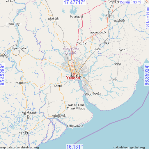
Yangon GPS coordinates[2]
16° 48' 19.008" North, 96° 9' 21.996" East
| Map corner | latitude | longitude |
|---|---|---|
| Upper-left | 17.47717°, | 95.45299° |
| Center: | 16.80528°, | 96.15611° |
| Lower-right: | 16.131°, | 96.85924° |
| Map W x H: | 149.7×149.7 km | = 93×93mi |
| max Lat: | 25.38327° ⇑64.9% North |
| Yangon: | 16.80528° |
| min Lat: | ⇓35.1% South 9.98238° |
| min Long | Yangon | max Long |
| 92.89835° | 96.15611° | 99.88083° |
| W 50%⇐ | ⇒50% E |
Elevation
Elevation of Yangon is 30 m = 98 ft, and this is 158.9 m = 521 ft below average elevation for this country.
| Max E: |
1768 m = 5801 ft | 55.4% |
| Avg. | 188.9 m = 620 ft | |
| Yangon | 30 m = 98 ft | |
Min E: |
5 m = 16 ft | 44.6% |
See also: Yangon elevation on elevation.city.
Geographical zone
Yangon is located in North Torrid zone (between Equator and Tropic of Cancer). Distance of this Northern Tropic circle is 737.3 km =458.1 mi to North.| Distance of | km | miles | from Yangon |
|---|---|---|---|
| North Pole | 8138.5 | 5057 | to North |
| Arctic Circle | 5532.6 | 3437.8 | to North |
| Tropic Cancer | 737.3 | 458.1 | to North |
| Equator | 1868.6 | 1161.1 | to South |


Nearby cities:
15 places around Yangon: (largest is in red/bold)
• Bago
68.3 km =42.4 mi,  30°
30°
• Bogale
98.8 km =61.4 mi,  234°
234°
• Kanbe
19.7 km =12.2 mi,  236°
236°
• Kayan
44.5 km =27.7 mi,  75°
75°
• Kyaiklat
61 km =37.9 mi, 228°
• Maubin
54 km =33.6 mi,  261°
261°
• Mawlamyinegyunn
106.2 km =66 mi, 243°
• Nyaungdon
61.1 km =38 mi,  295°
295°
• Pyapon
77 km =47.8 mi,  221°
221°
• Syriam
10.3 km =6.4 mi,  113°
113°
• Thanatpin
70 km =43.5 mi,  39°
39°
• Tharyarwady
102.1 km =63.4 mi,  337°
337°
• Thongwa
39.6 km =24.6 mi,  97°
97°
• Twante
26.4 km =16.4 mi,  246°
246°
• Wakema
106.1 km =65.9 mi, 257°
In other languages:
- In Spanish: Rangún
- In German: Rangun
- In Italian: Rangoon, Yangon
- In Russian: Янгон
- In Chinese: 仰光
Sources, notices
• [Note1] Compared only with cities in Myanmar existing in our database
• [Src1] Map data: © OpenStreetMap contributors (CC-BY-SA)
• [Src2] Other city data from geonames.org with taken over terms of usage.
• [Src3] Geographical zone / Annual Mean Temperature by Robert A. Rohde @ Wikipedia
