Bogale geodata
Bogale (Ayeyarwady) is a populated place; located in Myanmar in Asia/Yangon (GMT+6.5) time zone. With population of 68,938 people, there are 34 cities with bigger population in this country. Compared to other cities in Myanmar, 82.4% of cities are located further ↑North; 75.7% of cities are located further →East and 91.9% of cities have higher elevation than Bogale. Note1


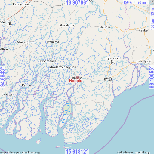
Bogale GPS coordinates[2]
16° 17' 38.94" North, 95° 23' 50.712" East
| Map corner | latitude | longitude |
|---|---|---|
| Upper-left | 16.96786°, | 94.6943° |
| Center: | 16.29415°, | 95.39742° |
| Lower-right: | 15.61812°, | 96.10055° |
| Map W x H: | 150.1×150.1 km | = 93.3×93.3mi |
| max Lat: | 25.38327° ⇑82.4% North |
| Bogale: | 16.29415° |
| min Lat: | ⇓17.6% South 9.98238° |
| min Long | Bogale | max Long |
| 92.89835° | 95.39742° | 99.88083° |
| W 24.3%⇐ | ⇒75.7% E |
Elevation
Elevation of Bogale is 11 m = 36 ft, and this is 177.9 m = 584 ft below average elevation for this country.
| Max E: |
1768 m = 5801 ft | 91.9% |
| Avg. | 188.9 m = 620 ft | |
| Bogale | 11 m = 36 ft | |
Min E: |
5 m = 16 ft | 8.1% |
See also: Bogale elevation on elevation.city.
Geographical zone
Bogale is located in North Torrid zone (between Equator and Tropic of Cancer). Distance of this Northern Tropic circle is 794.2 km =493.5 mi to North.| Distance of | km | miles | from Bogale |
|---|---|---|---|
| North Pole | 8195.3 | 5092.3 | to North |
| Arctic Circle | 5589.4 | 3473.1 | to North |
| Tropic Cancer | 794.2 | 493.5 | to North |
| Equator | 1811.7 | 1125.7 | to South |


Nearby cities:
15 places around Bogale: (largest is in red/bold)
• Hinthada
150.8 km =93.7 mi,  2°
2°
• Kanbe
79.1 km =49.2 mi,  54°
54°
• Kayan
141.5 km =87.9 mi,  61°
61°
• Kyaiklat
38.6 km =24 mi, 64°
• Maubin
55.8 km =34.7 mi,  29°
29°
• Mawlamyinegyunn
16.9 km =10.5 mi,  303°
303°
• Nyaungdon
87.3 km =54.2 mi,  17°
17°
• Pathein
89.1 km =55.4 mi,  307°
307°
• Pyapon
30 km =18.6 mi,  91°
91°
• Syriam
104.6 km =65 mi, 59°
• Tharyarwady
156.8 km =97.4 mi, 15°
• Thongwa
130.9 km =81.3 mi,  66°
66°
• Twante
73.1 km =45.4 mi, 50°
• Wakema
41.3 km =25.7 mi,  326°
326°
• Yangon
98.8 km =61.4 mi, 54°
Sources, notices
• [Note1] Compared only with cities in Myanmar existing in our database
• [Src1] Map data: © OpenStreetMap contributors (CC-BY-SA)
• [Src2] Other city data from geonames.org with taken over terms of usage.
• [Src3] Geographical zone / Annual Mean Temperature by Robert A. Rohde @ Wikipedia
