Senj geodata
Senj (East Gobi Aymag) is a seat of a second-order administrative division; located in Mongolia in Asia/Ulaanbaatar (GMT+8) time zone. In our database, there are 33 cities with bigger population. Compared to other cities in Mongolia, 92% of cities are located further ↑North; 89% of cities are located further ←West and 85% of cities have higher elevation than Senj. Note1


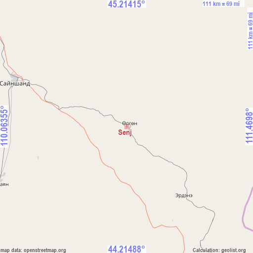
Senj GPS coordinates[2]
44° 43' 0.012" North, 110° 46' 0.012" East
| Map corner | latitude | longitude |
|---|---|---|
| Upper-left | 45.21415°, | 110.06355° |
| Center: | 44.71667°, | 110.76667° |
| Lower-right: | 44.21488°, | 111.4698° |
| Map W x H: | 111.1×111.1 km | = 69×69mi |
| max Lat: | 51.50725° ⇑92% North |
| Senj: | 44.71667° |
| min Lat: | ⇓8% South 42.84199° |
| min Long | Senj | max Long |
| 89.14358° | 110.76667° | 118.51014° |
| W 89%⇐ | ⇒11% E |
Elevation
Elevation of Senj is 1004 m = 3294 ft, and this is 412.5 m = 1353 ft below average elevation for this country.
| Max E: |
2800 m = 9186 ft | 85% |
| Avg. | 1416.5 m = 4647 ft | |
| Senj | 1004 m = 3294 ft | |
Min E: |
619 m = 2031 ft | 15% |
See also: Mongolia elevation on elevation.city.
Geographical zone
Senj is located in North temperate zone (between Tropic of Cancer and the Arctic Circle). Distance of this Northern Tropic circle is 2366.1 km =1470.2 mi to South.| Distance of | km | miles | from Senj |
|---|---|---|---|
| North Pole | 5035 | 3128.6 | to North |
| Arctic Circle | 2429.1 | 1509.4 | to North |
| Tropic Cancer | 2366.1 | 1470.2 | to South |
| Equator | 4972 | 3089.5 | to South |


Nearby cities:
15 places around Senj: (largest is in red/bold)
• Bayan
176.8 km =109.9 mi,  344°
344°
• Buyant
170.6 km =106 mi,  1°
1°
• Böhöt
203.6 km =126.5 mi,  286°
286°
• Chandmanĭ
93.8 km =58.3 mi,  345°
345°
• Hongor
125.1 km =77.7 mi,  15°
15°
• Khuvsget
152.8 km =94.9 mi,  216°
216°
• Naran-mandokhu Somon
202.5 km =125.8 mi,  259°
259°
• Nüden
128.3 km =79.7 mi,  190°
190°
• Saynshand
54.5 km =33.9 mi, 289°
• Sergelen
184.1 km =114.4 mi,  26°
26°
• Shireet
167.7 km =104.2 mi,  47°
47°
• Tsagaandörvölj
165.3 km =102.7 mi,  316°
316°
• Tsomog
188.3 km =117 mi, 315°
• Ulaan-Uul
56.4 km =35 mi,  139°
139°
• Öldziyt
138.4 km =86 mi,  268°
268°
Sources, notices
• [Note1] Compared only with cities in Mongolia existing in our database
• [Src1] Map data: © OpenStreetMap contributors (CC-BY-SA)
• [Src2] Other city data from geonames.org with taken over terms of usage.
• [Src3] Geographical zone / Annual Mean Temperature by Robert A. Rohde @ Wikipedia
