Shireet geodata
Shireet (Sühbaatar) is a seat of a second-order administrative division; located in Mongolia in Asia/Choibalsan (GMT+8) time zone. In our database, there are 33 cities with bigger population. Compared to other cities in Mongolia, 83.7% of cities are located further ↑North; 93.3% of cities are located further ←West and 76.4% of cities have higher elevation than Shireet. Note1


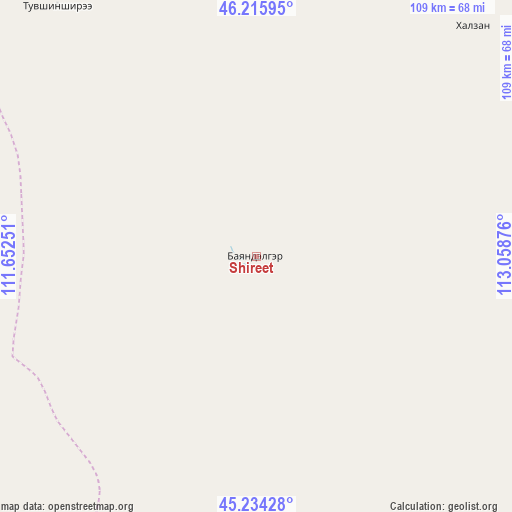
Shireet GPS coordinates[2]
45° 43' 38.172" North, 112° 21' 20.268" East
| Map corner | latitude | longitude |
|---|---|---|
| Upper-left | 46.21595°, | 111.65251° |
| Center: | 45.72727°, | 112.35563° |
| Lower-right: | 45.23428°, | 113.05876° |
| Map W x H: | 109.2×109.1 km | = 67.9×67.8mi |
| max Lat: | 51.50725° ⇑83.7% North |
| Shireet: | 45.72727° |
| min Lat: | ⇓16.3% South 42.84199° |
| min Long | Shireet | max Long |
| 89.14358° | 112.35563° | 118.51014° |
| W 93.3%⇐ | ⇒6.7% E |
Elevation
Elevation of Shireet is 1096 m = 3596 ft, and this is 320.5 m = 1052 ft below average elevation for this country.
| Max E: |
2800 m = 9186 ft | 76.4% |
| Avg. | 1416.5 m = 4647 ft | |
| Shireet | 1096 m = 3596 ft | |
Min E: |
619 m = 2031 ft | 23.6% |
See also: Mongolia elevation on elevation.city.
Geographical zone
Shireet is located in North temperate zone (between Tropic of Cancer and the Arctic Circle). Distance of this North polar circle is 2316.8 km =1439.6 mi to North.| Distance of | km | miles | from Shireet |
|---|---|---|---|
| North Pole | 4922.7 | 3058.8 | to North |
| Arctic Circle | 2316.8 | 1439.6 | to North |
| Tropic Cancer | 2478.5 | 1540.1 | to South |
| Equator | 5084.4 | 3159.3 | to South |


Nearby cities:
15 places around Shireet: (largest is in red/bold)
• Baruun-Urt
127.6 km =79.3 mi,  33°
33°
• Bayasgalant
141.6 km =88 mi,  350°
350°
• Buyant
131.2 km =81.5 mi,  296°
296°
• Chandmanĭ
148.4 km =92.2 mi,  261°
261°
• Dzüünbulag
74.1 km =46 mi, 349°
• Hatavch
67.1 km =41.7 mi,  43°
43°
• Havirga
56.9 km =35.4 mi,  96°
96°
• Haylaastay
165.1 km =102.6 mi,  45°
45°
• Hongor
90 km =55.9 mi,  275°
275°
• Hongor
122.8 km =76.3 mi,  122°
122°
• Ovoot
125.6 km =78 mi,  112°
112°
• Senj
167.7 km =104.2 mi,  227°
227°
• Sergelen
67.1 km =41.7 mi,  321°
321°
• Ulaan-Uul
178.3 km =110.8 mi,  209°
209°
• Ulaandel
117.9 km =73.3 mi, 53°
Sources, notices
• [Note1] Compared only with cities in Mongolia existing in our database
• [Src1] Map data: © OpenStreetMap contributors (CC-BY-SA)
• [Src2] Other city data from geonames.org with taken over terms of usage.
• [Src3] Geographical zone / Annual Mean Temperature by Robert A. Rohde @ Wikipedia
