Chandmanĭ geodata
Chandmanĭ (East Gobi Aymag) is a seat of a second-order administrative division; located in Mongolia in Asia/Ulaanbaatar (GMT+8) time zone. In our database, there are 33 cities with bigger population. Compared to other cities in Mongolia, 85.9% of cities are located further ↑North; 87.4% of cities are located further ←West and 87.4% of cities have higher elevation than Chandmanĭ. Note1


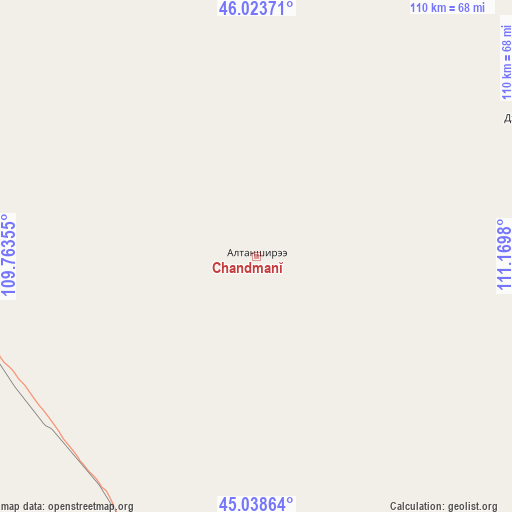
Chandmanĭ GPS coordinates[2]
45° 31' 59.988" North, 110° 28' 0.012" East
| Map corner | latitude | longitude |
|---|---|---|
| Upper-left | 46.02371°, | 109.76355° |
| Center: | 45.53333°, | 110.46667° |
| Lower-right: | 45.03864°, | 111.1698° |
| Map W x H: | 109.5×109.5 km | = 68×68mi |
| max Lat: | 51.50725° ⇑85.9% North |
| Chandmanĭ: | 45.53333° |
| min Lat: | ⇓14.1% South 42.84199° |
| min Long | Chandmanĭ | max Long |
| 89.14358° | 110.46667° | 118.51014° |
| W 87.4%⇐ | ⇒12.6% E |
Elevation
Elevation of Chandmanĭ is 956 m = 3136 ft, and this is 460.5 m = 1511 ft below average elevation for this country.
| Max E: |
2800 m = 9186 ft | 87.4% |
| Avg. | 1416.5 m = 4647 ft | |
| Chandmanĭ | 956 m = 3136 ft | |
Min E: |
619 m = 2031 ft | 12.6% |
See also: Mongolia elevation on elevation.city.
Geographical zone
Chandmanĭ is located in North temperate zone (between Tropic of Cancer and the Arctic Circle). Distance of this North polar circle is 2338.3 km =1453 mi to North.| Distance of | km | miles | from Chandmanĭ |
|---|---|---|---|
| North Pole | 4944.2 | 3072.2 | to North |
| Arctic Circle | 2338.3 | 1453 | to North |
| Tropic Cancer | 2456.9 | 1526.6 | to South |
| Equator | 5062.8 | 3145.9 | to South |


Nearby cities:
15 places around Chandmanĭ: (largest is in red/bold)
• Bayan
83 km =51.6 mi,  343°
343°
• Buyant
84.6 km =52.6 mi,  19°
19°
• Darhan
145.1 km =90.2 mi,  326°
326°
• Dzüünbulag
162.9 km =101.2 mi,  54°
54°
• Hongor
64.2 km =39.9 mi,  62°
62°
• Saynshand
77.4 km =48.1 mi,  200°
200°
• Senj
93.8 km =58.3 mi,  165°
165°
• Sergelen
128.1 km =79.6 mi, 54°
• Shireet
148.4 km =92.2 mi,  81°
81°
• Shiveegovĭ
156.6 km =97.3 mi,  293°
293°
• Tsagaandörvölj
94 km =58.4 mi, 288°
• Tsomog
116.7 km =72.5 mi, 291°
• Ulaan-Ereg
161.7 km =100.5 mi, 340°
• Ulaan-Uul
146.4 km =91 mi,  155°
155°
• Öldziyt
147.9 km =91.9 mi,  230°
230°
Sources, notices
• [Note1] Compared only with cities in Mongolia existing in our database
• [Src1] Map data: © OpenStreetMap contributors (CC-BY-SA)
• [Src2] Other city data from geonames.org with taken over terms of usage.
• [Src3] Geographical zone / Annual Mean Temperature by Robert A. Rohde @ Wikipedia
