Undurkhaan geodata
Undurkhaan (Hentiy) is a seat of a first-order administrative division; located in Mongolia in Asia/Ulaanbaatar (GMT+8) time zone. With population of 14,723 people, there are 21 cities with bigger population in this country. Compared to other cities in Mongolia, 56.1% of cities are located further ↑North; 88.7% of cities are located further ←West and 82.2% of cities have higher elevation than Undurkhaan. Note1


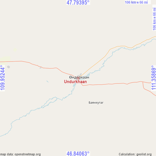
Undurkhaan GPS coordinates[2]
47° 19' 9.984" North, 110° 39' 20.016" East
| Map corner | latitude | longitude |
|---|---|---|
| Upper-left | 47.79395°, | 109.95244° |
| Center: | 47.31944°, | 110.65556° |
| Lower-right: | 46.84063°, | 111.35869° |
| Map W x H: | 106×106 km | = 65.9×65.9mi |
| max Lat: | 51.50725° ⇑56.1% North |
| Undurkhaan: | 47.31944° |
| min Lat: | ⇓43.9% South 42.84199° |
| min Long | Undurkhaan | max Long |
| 89.14358° | 110.65556° | 118.51014° |
| W 88.7%⇐ | ⇒11.3% E |
Elevation
Elevation of Undurkhaan is 1030 m = 3379 ft, and this is 386.5 m = 1268 ft below average elevation for this country.
| Max E: |
2800 m = 9186 ft | 82.2% |
| Avg. | 1416.5 m = 4647 ft | |
| Undurkhaan | 1030 m = 3379 ft | |
Min E: |
619 m = 2031 ft | 17.8% |
See also: Mongolia elevation on elevation.city.
Geographical zone
Undurkhaan is located in North temperate zone (between Tropic of Cancer and the Arctic Circle). Distance of this North polar circle is 2139.7 km =1329.5 mi to North.| Distance of | km | miles | from Undurkhaan |
|---|---|---|---|
| North Pole | 4745.6 | 2948.8 | to North |
| Arctic Circle | 2139.7 | 1329.5 | to North |
| Tropic Cancer | 2655.5 | 1650.1 | to South |
| Equator | 5261.4 | 3269.3 | to South |


Nearby cities:
15 places around Undurkhaan: (largest is in red/bold)
• Avraga
111.7 km =69.4 mi,  261°
261°
• Bayan
20.9 km =13 mi,  144°
144°
• Bayan
124.6 km =77.4 mi,  197°
197°
• Bayan
140.5 km =87.3 mi,  13°
13°
• Bayanbulag
82.3 km =51.1 mi,  317°
317°
• Bayasgalant
111.9 km =69.5 mi,  109°
109°
• Buyant
119.7 km =74.4 mi,  173°
173°
• Darhan
122.2 km =75.9 mi,  230°
230°
• Dundbürd
94 km =58.4 mi,  42°
42°
• Hanhöhiy
115.9 km =72 mi,  73°
73°
• Herlen
7 km =4.3 mi,  252°
252°
• Javhlant
121.2 km =75.3 mi,  64°
64°
• Modot
129.7 km =80.6 mi,  291°
291°
• Mörön
26.5 km =16.5 mi, 285°
• Ulaan-Ereg
82.9 km =51.5 mi,  235°
235°
Sources, notices
• [Note1] Compared only with cities in Mongolia existing in our database
• [Src1] Map data: © OpenStreetMap contributors (CC-BY-SA)
• [Src2] Other city data from geonames.org with taken over terms of usage.
• [Src3] Geographical zone / Annual Mean Temperature by Robert A. Rohde @ Wikipedia
