Bayan geodata
Bayan (Hentiy) is a seat of a second-order administrative division; located in Mongolia in Asia/Ulaanbaatar (GMT+8) time zone. In our database, there are 33 cities with bigger population. Compared to other cities in Mongolia, 67.5% of cities are located further ↓South; 89.9% of cities are located further ←West and 79.8% of cities have higher elevation than Bayan. Note1


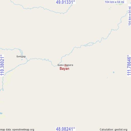
Bayan GPS coordinates[2]
48° 33' 0" North, 111° 4' 59.988" East
| Map corner | latitude | longitude |
|---|---|---|
| Upper-left | 49.01331°, | 110.38021° |
| Center: | 48.55°, | 111.08333° |
| Lower-right: | 48.08241°, | 111.78646° |
| Map W x H: | 103.5×103.5 km | = 64.3×64.3mi |
| max Lat: | 51.50725° ⇑32.5% North |
| Bayan: | 48.55° |
| min Lat: | ⇓67.5% South 42.84199° |
| min Long | Bayan | max Long |
| 89.14358° | 111.08333° | 118.51014° |
| W 89.9%⇐ | ⇒10.1% E |
Elevation
Elevation of Bayan is 1050 m = 3445 ft, and this is 366.5 m = 1202 ft below average elevation for this country.
| Max E: |
2800 m = 9186 ft | 79.8% |
| Avg. | 1416.5 m = 4647 ft | |
| Bayan | 1050 m = 3445 ft | |
Min E: |
619 m = 2031 ft | 20.2% |
See also: Mongolia elevation on elevation.city.
Geographical zone
Bayan is located in North temperate zone (between Tropic of Cancer and the Arctic Circle). Distance of this North polar circle is 2002.9 km =1244.5 mi to North.| Distance of | km | miles | from Bayan |
|---|---|---|---|
| North Pole | 4608.8 | 2863.8 | to North |
| Arctic Circle | 2002.9 | 1244.5 | to North |
| Tropic Cancer | 2792.3 | 1735.1 | to South |
| Equator | 5398.3 | 3354.3 | to South |


Nearby cities:
15 places around Bayan: (largest is in red/bold)
• Bayan
155.1 km =96.4 mi,  116°
116°
• Bayan
155.1 km =96.4 mi,  187°
187°
• Bayan-Ovoo
65.7 km =40.8 mi,  37°
37°
• Bayanbulag
115.1 km =71.5 mi,  228°
228°
• Dundbürd
73.8 km =45.9 mi,  155°
155°
• Eg
67.8 km =42.1 mi,  282°
282°
• Hanhöhiy
129.8 km =80.7 mi,  143°
143°
• Herlen
144.2 km =89.6 mi,  195°
195°
• Javarthushuu
137.9 km =85.7 mi,  61°
61°
• Javhlant
114.6 km =71.2 mi, 138°
• Mörön
141.8 km =88.1 mi, 203°
• Onon
36.3 km =22.6 mi, 281°
• Tsagaan-Owoo
174 km =108.1 mi,  95°
95°
• Uldz
68.8 km =42.8 mi,  76°
76°
• Undurkhaan
140.5 km =87.3 mi, 193°
Sources, notices
• [Note1] Compared only with cities in Mongolia existing in our database
• [Src1] Map data: © OpenStreetMap contributors (CC-BY-SA)
• [Src2] Other city data from geonames.org with taken over terms of usage.
• [Src3] Geographical zone / Annual Mean Temperature by Robert A. Rohde @ Wikipedia
