Hanhöhiy geodata
Hanhöhiy (Sühbaatar) is a seat of a second-order administrative division; located in Mongolia in Asia/Choibalsan (GMT+8) time zone. In our database, there are 33 cities with bigger population. Compared to other cities in Mongolia, 51.2% of cities are located further ↑North; 92.6% of cities are located further ←West and 72.4% of cities have higher elevation than Hanhöhiy. Note1


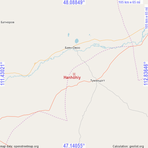
Hanhöhiy GPS coordinates[2]
47° 37' 0.012" North, 112° 7' 59.988" East
| Map corner | latitude | longitude |
|---|---|---|
| Upper-left | 48.08849°, | 111.43021° |
| Center: | 47.61667°, | 112.13333° |
| Lower-right: | 47.14055°, | 112.83646° |
| Map W x H: | 105.4×105.4 km | = 65.5×65.5mi |
| max Lat: | 51.50725° ⇑51.2% North |
| Hanhöhiy: | 47.61667° |
| min Lat: | ⇓48.8% South 42.84199° |
| min Long | Hanhöhiy | max Long |
| 89.14358° | 112.13333° | 118.51014° |
| W 92.6%⇐ | ⇒7.4% E |
Elevation
Elevation of Hanhöhiy is 1139 m = 3737 ft, and this is 277.5 m = 910 ft below average elevation for this country.
| Max E: |
2800 m = 9186 ft | 72.4% |
| Avg. | 1416.5 m = 4647 ft | |
| Hanhöhiy | 1139 m = 3737 ft | |
Min E: |
619 m = 2031 ft | 27.6% |
See also: Mongolia elevation on elevation.city.
Geographical zone
Hanhöhiy is located in North temperate zone (between Tropic of Cancer and the Arctic Circle). Distance of this North polar circle is 2106.7 km =1309 mi to North.| Distance of | km | miles | from Hanhöhiy |
|---|---|---|---|
| North Pole | 4712.6 | 2928.3 | to North |
| Arctic Circle | 2106.7 | 1309 | to North |
| Tropic Cancer | 2688.6 | 1670.6 | to South |
| Equator | 5294.5 | 3289.8 | to South |


Nearby cities:
15 places around Hanhöhiy: (largest is in red/bold)
• Baruun-Urt
135.4 km =84.1 mi,  140°
140°
• Bayan
69.6 km =43.2 mi,  61°
61°
• Bayan
111 km =69 mi,  243°
243°
• Bayan
129.8 km =80.7 mi,  323°
323°
• Bayasgalant
70.7 km =43.9 mi,  185°
185°
• Dundbürd
60 km =37.3 mi,  307°
307°
• Dzüünbulag
137.2 km =85.3 mi,  178°
178°
• Herlen
122.9 km =76.4 mi,  253°
253°
• Javhlant
18.6 km =11.6 mi,  356°
356°
• Mörön
138.9 km =86.3 mi,  259°
259°
• Onon
159.1 km =98.9 mi, 314°
• Tsagaan-Owoo
130.1 km =80.8 mi,  47°
47°
• Uldz
119.8 km =74.4 mi, 355°
• Undurkhaan
115.9 km =72 mi, 253°
• Öndörhoshuu
141 km =87.6 mi,  72°
72°
Sources, notices
• [Note1] Compared only with cities in Mongolia existing in our database
• [Src1] Map data: © OpenStreetMap contributors (CC-BY-SA)
• [Src2] Other city data from geonames.org with taken over terms of usage.
• [Src3] Geographical zone / Annual Mean Temperature by Robert A. Rohde @ Wikipedia
