Mandal geodata
Mandal (Hövsgöl) is a seat of a second-order administrative division; located in Mongolia in Asia/Ulaanbaatar (GMT+8) time zone. In our database, there are 33 cities with bigger population. Compared to other cities in Mongolia, 93.3% of cities are located further ↓South; 68.4% of cities are located further →East and 87.4% of cities have lower elevation than Mandal. Note1


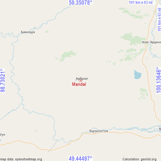
Mandal GPS coordinates[2]
49° 54' 0" North, 99° 25' 59.988" East
| Map corner | latitude | longitude |
|---|---|---|
| Upper-left | 50.35078°, | 98.73021° |
| Center: | 49.9°, | 99.43333° |
| Lower-right: | 49.44497°, | 100.13646° |
| Map W x H: | 100.7×100.7 km | = 62.6×62.6mi |
| max Lat: | 51.50725° ⇑6.7% North |
| Mandal: | 49.9° |
| min Lat: | ⇓93.3% South 42.84199° |
| min Long | Mandal | max Long |
| 89.14358° | 99.43333° | 118.51014° |
| W 31.6%⇐ | ⇒68.4% E |
Elevation
Elevation of Mandal is 1946 m = 6385 ft, and this is 529.5 m = 1737 ft above average elevation for this country.
| Max E: |
2800 m = 9186 ft | 12.6% |
| Mandal | 1946 m 6385 ft | |
| Avg. | 1416.5 m = 4647 ft | |
Min E: |
619 m = 2031 ft | 87.4% |
See also: Mongolia elevation on elevation.city.
Geographical zone
Mandal is located in North temperate zone (between Tropic of Cancer and the Arctic Circle). Distance of this North polar circle is 1852.8 km =1151.3 mi to North.| Distance of | km | miles | from Mandal |
|---|---|---|---|
| North Pole | 4458.7 | 2770.5 | to North |
| Arctic Circle | 1852.8 | 1151.3 | to North |
| Tropic Cancer | 2942.4 | 1828.3 | to South |
| Equator | 5548.4 | 3447.6 | to South |


Nearby cities:
15 places around Mandal: (largest is in red/bold)
• Altraga
45.3 km =28.1 mi,  313°
313°
• Bayan
53.3 km =33.1 mi,  166°
166°
• Bayan-Uhaa
139.3 km =86.6 mi,  199°
199°
• Bulag
85.6 km =53.2 mi,  93°
93°
• Dzöölön
135.3 km =84.1 mi,  7°
7°
• Erdenet
106 km =65.9 mi,  175°
175°
• Halban
128.5 km =79.8 mi,  251°
251°
• Ider
129.3 km =80.3 mi, 165°
• Jargalant
89.6 km =55.7 mi,  138°
138°
• Manhan
50 km =31.1 mi,  60°
60°
• Murun-kuren
60.1 km =37.3 mi,  119°
119°
• Sharga
46.7 km =29 mi,  256°
256°
• Tsengel
114.8 km =71.3 mi,  114°
114°
• Undur Sume
124 km =77.1 mi, 59°
• Vlaa Vula
88.2 km =54.8 mi,  350°
350°
Sources, notices
• [Note1] Compared only with cities in Mongolia existing in our database
• [Src1] Map data: © OpenStreetMap contributors (CC-BY-SA)
• [Src2] Other city data from geonames.org with taken over terms of usage.
• [Src3] Geographical zone / Annual Mean Temperature by Robert A. Rohde @ Wikipedia
