Manhan geodata
Manhan (Hövsgöl) is a seat of a second-order administrative division; located in Mongolia in Asia/Ulaanbaatar (GMT+8) time zone. In our database, there are 33 cities with bigger population. Compared to other cities in Mongolia, 96% of cities are located further ↓South; 65.6% of cities are located further →East and 67.8% of cities have lower elevation than Manhan. Note1


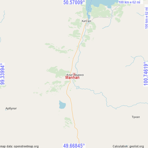
Manhan GPS coordinates[2]
50° 7' 17.004" North, 100° 2' 35.016" East
| Map corner | latitude | longitude |
|---|---|---|
| Upper-left | 50.57009°, | 99.33994° |
| Center: | 50.12139°, | 100.04306° |
| Lower-right: | 49.66845°, | 100.74619° |
| Map W x H: | 100.3×100.3 km | = 62.3×62.3mi |
| max Lat: | 51.50725° ⇑4% North |
| Manhan: | 50.12139° |
| min Lat: | ⇓96% South 42.84199° |
| min Long | Manhan | max Long |
| 89.14358° | 100.04306° | 118.51014° |
| W 34.4%⇐ | ⇒65.6% E |
Elevation
Elevation of Manhan is 1579 m = 5180 ft, and this is 162.5 m = 533 ft above average elevation for this country.
| Max E: |
2800 m = 9186 ft | 32.2% |
| Manhan | 1579 m 5180 ft | |
| Avg. | 1416.5 m = 4647 ft | |
Min E: |
619 m = 2031 ft | 67.8% |
See also: Mongolia elevation on elevation.city.
Geographical zone
Manhan is located in North temperate zone (between Tropic of Cancer and the Arctic Circle). Distance of this North polar circle is 1828.2 km =1136 mi to North.| Distance of | km | miles | from Manhan |
|---|---|---|---|
| North Pole | 4434.1 | 2755.2 | to North |
| Arctic Circle | 1828.2 | 1136 | to North |
| Tropic Cancer | 2967.1 | 1843.7 | to South |
| Equator | 5573 | 3462.9 | to South |


Nearby cities:
15 places around Manhan: (largest is in red/bold)
• Altraga
76.6 km =47.6 mi,  274°
274°
• Bayan
82.9 km =51.5 mi,  202°
202°
• Bulag
50.9 km =31.6 mi,  124°
124°
• Bulgan
114.4 km =71.1 mi,  65°
65°
• Dzöölön
112.7 km =70 mi,  346°
346°
• Eg-Uur
109.3 km =67.9 mi,  90°
90°
• Erdenet
135.4 km =84.1 mi, 195°
• Jargalant
93.1 km =57.8 mi,  170°
170°
• Mandal
50 km =31.1 mi,  240°
240°
• Murun-kuren
54.8 km =34.1 mi, 171°
• Selenge
127.7 km =79.3 mi,  126°
126°
• Sharga
95.8 km =59.5 mi,  248°
248°
• Tsengel
93.8 km =58.3 mi,  139°
139°
• Undur Sume
74 km =46 mi,  58°
58°
• Vlaa Vula
84.8 km =52.7 mi,  317°
317°
Sources, notices
• [Note1] Compared only with cities in Mongolia existing in our database
• [Src1] Map data: © OpenStreetMap contributors (CC-BY-SA)
• [Src2] Other city data from geonames.org with taken over terms of usage.
• [Src3] Geographical zone / Annual Mean Temperature by Robert A. Rohde @ Wikipedia
