Tögrög geodata
Tögrög (Hovd) is a seat of a second-order administrative division; located in Mongolia in Asia/Hovd (GMT+7) time zone. In our database, there are 33 cities with bigger population. Compared to other cities in Mongolia, 54% of cities are located further ↑North; 91.1% of cities are located further →East and 52.1% of cities have higher elevation than Tögrög. Note1


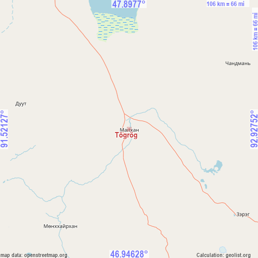
Tögrög GPS coordinates[2]
47° 25' 26.904" North, 92° 13' 27.804" East
| Map corner | latitude | longitude |
|---|---|---|
| Upper-left | 47.8977°, | 91.52127° |
| Center: | 47.42414°, | 92.22439° |
| Lower-right: | 46.94628°, | 92.92752° |
| Map W x H: | 105.8×105.8 km | = 65.7×65.7mi |
| max Lat: | 51.50725° ⇑54% North |
| Tögrög: | 47.42414° |
| min Lat: | ⇓46% South 42.84199° |
| min Long | Tögrög | max Long |
| 89.14358° | 92.22439° | 118.51014° |
| W 8.9%⇐ | ⇒91.1% E |
Elevation
Elevation of Tögrög is 1350 m = 4429 ft, and this is 66.5 m = 218 ft below average elevation for this country.
| Max E: |
2800 m = 9186 ft | 52.1% |
| Avg. | 1416.5 m = 4647 ft | |
| Tögrög | 1350 m = 4429 ft | |
Min E: |
619 m = 2031 ft | 47.9% |
See also: Mongolia elevation on elevation.city.
Geographical zone
Tögrög is located in North temperate zone (between Tropic of Cancer and the Arctic Circle). Distance of this North polar circle is 2128.1 km =1322.3 mi to North.| Distance of | km | miles | from Tögrög |
|---|---|---|---|
| North Pole | 4734 | 2941.6 | to North |
| Arctic Circle | 2128.1 | 1322.3 | to North |
| Tropic Cancer | 2667.2 | 1657.3 | to South |
| Equator | 5273.1 | 3276.6 | to South |


Nearby cities:
15 places around Tögrög: (largest is in red/bold)
• Altanteel
58.3 km =36.2 mi,  126°
126°
• Bayanhoshuu
92.9 km =57.7 mi,  345°
345°
• Buyant
77.7 km =48.3 mi,  336°
336°
• Bürenhayrhan
156.8 km =97.4 mi,  199°
199°
• Darvi
118.4 km =73.6 mi,  117°
117°
• Duut
45.6 km =28.3 mi,  283°
283°
• Har-Us
131.7 km =81.8 mi,  333°
333°
• Jargalant
102.2 km =63.5 mi,  237°
237°
• Khovd
78 km =48.5 mi, 326°
• Rashaant
111 km =69 mi,  290°
290°
• Tsenher
57 km =35.4 mi,  188°
188°
• Tsetsegnuur
121 km =75.2 mi,  139°
139°
• Ulaantolgoy
92.6 km =57.5 mi,  152°
152°
• Urdgol
55.6 km =34.5 mi,  35°
35°
• Uyenchi Somon
153.6 km =95.4 mi, 185°
Sources, notices
• [Note1] Compared only with cities in Mongolia existing in our database
• [Src1] Map data: © OpenStreetMap contributors (CC-BY-SA)
• [Src2] Other city data from geonames.org with taken over terms of usage.
• [Src3] Geographical zone / Annual Mean Temperature by Robert A. Rohde @ Wikipedia
