Tsagaannuur geodata
Tsagaannuur (Hövsgöl) is a seat of a second-order administrative division; located in Mongolia in Asia/Ulaanbaatar (GMT+8) time zone. In our database, there are 33 cities with bigger population. Compared to other cities in Mongolia, 99.7% of cities are located further ↓South; 69.3% of cities are located further →East and 66% of cities have lower elevation than Tsagaannuur. Note1


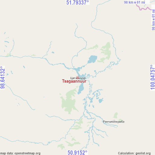
Tsagaannuur GPS coordinates[2]
51° 21' 23.004" North, 99° 20' 39.984" East
| Map corner | latitude | longitude |
|---|---|---|
| Upper-left | 51.79337°, | 98.64132° |
| Center: | 51.35639°, | 99.34444° |
| Lower-right: | 50.9152°, | 100.04757° |
| Map W x H: | 97.6×97.6 km | = 60.6×60.6mi |
| max Lat: | 51.50725° ⇑0.3% North |
| Tsagaannuur: | 51.35639° |
| min Lat: | ⇓99.7% South 42.84199° |
| min Long | Tsagaannuur | max Long |
| 89.14358° | 99.34444° | 118.51014° |
| W 30.7%⇐ | ⇒69.3% E |
Elevation
Elevation of Tsagaannuur is 1546 m = 5072 ft, and this is 129.5 m = 425 ft above average elevation for this country.
| Max E: |
2800 m = 9186 ft | 34% |
| Tsagaannuur | 1546 m 5072 ft | |
| Avg. | 1416.5 m = 4647 ft | |
Min E: |
619 m = 2031 ft | 66% |
See also: Mongolia elevation on elevation.city.
Geographical zone
Tsagaannuur is located in North temperate zone (between Tropic of Cancer and the Arctic Circle). Distance of this North polar circle is 1690.9 km =1050.7 mi to North.| Distance of | km | miles | from Tsagaannuur |
|---|---|---|---|
| North Pole | 4296.8 | 2669.9 | to North |
| Arctic Circle | 1690.9 | 1050.7 | to North |
| Tropic Cancer | 3104.4 | 1929 | to South |
| Equator | 5710.3 | 3548.2 | to South |


Nearby cities:
15 places around Tsagaannuur: (largest is in red/bold)
• Altraga
133.5 km =83 mi,  191°
191°
• Bayan
214.6 km =133.3 mi,  175°
175°
• Bulag
189.4 km =117.7 mi,  151°
151°
• Bulgan
176.9 km =109.9 mi,  120°
120°
• Dzöölön
35.9 km =22.3 mi,  140°
140°
• Eg-Uur
209.4 km =130.1 mi,  131°
131°
• Halban
232.8 km =144.7 mi,  209°
209°
• Mandal
162.1 km =100.7 mi, 177°
• Manhan
145.9 km =90.7 mi,  160°
160°
• Murun-kuren
200 km =124.3 mi, 163°
• Sharga
177.3 km =110.2 mi, 192°
• Tsengel
235.8 km =146.5 mi, 152°
• Turt
92.9 km =57.7 mi,  79°
79°
• Undur Sume
148.2 km =92.1 mi, 131°
• Vlaa Vula
75.2 km =46.7 mi, 185°
Sources, notices
• [Note1] Compared only with cities in Mongolia existing in our database
• [Src1] Map data: © OpenStreetMap contributors (CC-BY-SA)
• [Src2] Other city data from geonames.org with taken over terms of usage.
• [Src3] Geographical zone / Annual Mean Temperature by Robert A. Rohde @ Wikipedia
