Hithadhoo geodata
Hithadhoo (Seenu) is a populated place; located in Maldives in Indian/Maldives (GMT+5) time zone. With population of 9,927 people, there are 2 cities with bigger population in this country. Compared to other cities in Maldives, 100% of cities are located further ↑North; 75% of cities are located further →East and 85.7% of cities have higher elevation than Hithadhoo. Note1


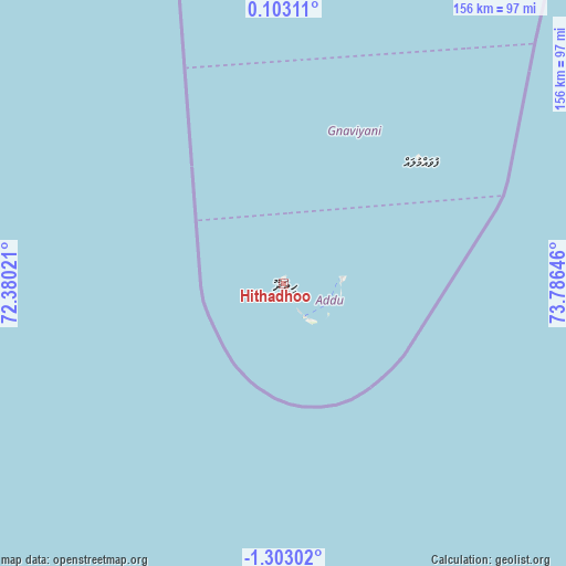
Hithadhoo GPS coordinates[2]
0° 36' 0" South, 73° 4' 59.988" East
| Map corner | latitude | longitude |
|---|---|---|
| Upper-left | 0.10311°, | 72.38021° |
| Center: | -0.6°, | 73.08333° |
| Lower-right: | -1.30302°, | 73.78646° |
| Map W x H: | 156.3×156.4 km | = 97.1×97.2mi |
| max Lat: | 6.88744° ⇑100% North |
| Hithadhoo: | -0.6° |
| min Lat: | ⇓0% South -0.6° |
| min Long | Hithadhoo | max Long |
| 72.89437° | 73.08333° | 73.56667° |
| W 25%⇐ | ⇒75% E |
Elevation
Elevation of Hithadhoo is 6 m = 20 ft, and this is 1.3 m = 4 ft below average elevation for this country.
| Max E: |
12 m = 39 ft | 85.7% |
| Avg. | 7.3 m = 24 ft | |
| Hithadhoo | 6 m = 20 ft | |
Min E: |
-1 m = -3 ft | 14.3% |
See also: Maldives elevation on elevation.city.
Geographical zone
Hithadhoo is located in South Torrid zone (between Equator and Tropic of Capricorn). Distance of Equator is 66.7 km =41.4 mi to North.| Distance of | km | miles | from Hithadhoo |
|---|---|---|---|
| Equator | 66.7 | 41.4 | to North |
| Tropic Capricorn | 2539.2 | 1577.8 | to South |
| Antarctic Circle | 7334.5 | 4557.4 | to South |
| South Pole | 9940.3 | 6176.6 | to South |


Nearby cities:
14 places around Hithadhoo: (largest is in red/bold)
• Buruni
351.3 km =218.3 mi,  0°
0°
• Diyamigili
328.2 km =203.9 mi, 4°
• Fonadhoo
274.4 km =170.5 mi,  9°
9°
• Fuvahmulah
50.6 km =31.4 mi,  48°
48°
• Guraidhoo
326.2 km =202.7 mi, 4°
• Hithadhoo
268.6 km =166.9 mi, 7°
• Kudahuvadhoo
364.3 km =226.4 mi,  356°
356°
• Madifushi
330 km =205.1 mi, 5°
• Meedhoo
16.8 km =10.4 mi,  83°
83°
• Muli
394.7 km =245.3 mi, 7°
• Thinadhoo
126.1 km =78.4 mi, 355°
• Veymandoo
310 km =192.6 mi, 0°
• Viligili
156 km =96.9 mi, 14°
• Vilufushi
345.9 km =214.9 mi, 4°
Sources, notices
• [Note1] Compared only with cities in Maldives existing in our database
• [Src1] Map data: © OpenStreetMap contributors (CC-BY-SA)
• [Src2] Other city data from geonames.org with taken over terms of usage.
• [Src3] Geographical zone / Annual Mean Temperature by Robert A. Rohde @ Wikipedia
