Fuvahmulah geodata
Fuvahmulah (Gnyaviyani Atoll) is a seat of a first-order administrative division; located in Maldives in Indian/Maldives (GMT+5) time zone. With population of 11,140 people, there is 1 city with bigger population in this country. Compared to other cities in Maldives, 92.9% of cities are located further ↑North; 71.4% of cities are located further ←West and 60.7% of cities have lower elevation than Fuvahmulah. Note1


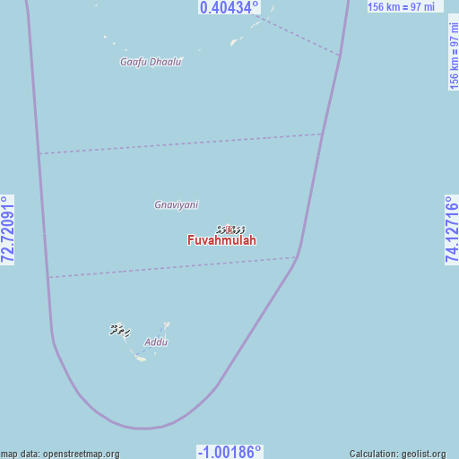
Fuvahmulah GPS coordinates[2]
0° 17' 55.608" South, 73° 25' 26.508" East
| Map corner | latitude | longitude |
|---|---|---|
| Upper-left | 0.40434°, | 72.72091° |
| Center: | -0.29878°, | 73.42403° |
| Lower-right: | -1.00186°, | 74.12716° |
| Map W x H: | 156.4×156.4 km | = 97.2×97.2mi |
| max Lat: | 6.88744° ⇑92.9% North |
| Fuvahmulah: | -0.29878° |
| min Lat: | ⇓7.1% South -0.6° |
| min Long | Fuvahmulah | max Long |
| 72.89437° | 73.42403° | 73.56667° |
| W 71.4%⇐ | ⇒28.6% E |
Elevation
Elevation of Fuvahmulah is 9 m = 30 ft, and this is 1.7 m = 6 ft above average elevation for this country.
| Max E: |
12 m = 39 ft | 39.3% |
| Fuvahmulah | 9 m 30 ft | |
| Avg. | 7.3 m = 24 ft | |
Min E: |
-1 m = -3 ft | 60.7% |
See also: Maldives elevation on elevation.city.
Geographical zone
Fuvahmulah is located in South Torrid zone (between Equator and Tropic of Capricorn). Distance of Equator is 33.2 km =20.6 mi to North.| Distance of | km | miles | from Fuvahmulah |
|---|---|---|---|
| Equator | 33.2 | 20.6 | to North |
| Tropic Capricorn | 2572.7 | 1598.6 | to South |
| Antarctic Circle | 7368 | 4578.3 | to South |
| South Pole | 9973.8 | 6197.4 | to South |


Nearby cities:
15 places around Fuvahmulah: (largest is in red/bold)
• Buruni
319.7 km =198.7 mi,  353°
353°
• Diyamigili
293.6 km =182.4 mi,  358°
358°
• Felidhoo
419.5 km =260.7 mi,  1°
1°
• Fonadhoo
237.1 km =147.3 mi, 2°
• Guraidhoo
291.9 km =181.4 mi, 357°
• Hithadhoo
50.6 km =31.4 mi,  228°
228°
• Hithadhoo
233 km =144.8 mi, 359°
• Kudahuvadhoo
335.4 km =208.4 mi, 349°
• Madifushi
295.3 km =183.5 mi, 358°
• Meedhoo
38.1 km =23.7 mi,  213°
213°
• Muli
357.9 km =222.4 mi, 2°
• Thinadhoo
103.6 km =64.4 mi,  332°
332°
• Veymandoo
278.9 km =173.3 mi, 352°
• Viligili
117.6 km =73.1 mi, 0°
• Vilufushi
311.8 km =193.7 mi, 357°
Sources, notices
• [Note1] Compared only with cities in Maldives existing in our database
• [Src1] Map data: © OpenStreetMap contributors (CC-BY-SA)
• [Src2] Other city data from geonames.org with taken over terms of usage.
• [Src3] Geographical zone / Annual Mean Temperature by Robert A. Rohde @ Wikipedia
