Atlixtac geodata
Atlixtac (Guerrero) is a populated place; located in Mexico in America/Mexico_City (GMT-6) time zone. With population of 936 people, there are 9311 cities with bigger population in this country. Compared to other cities in Mexico, 81.8% of cities are located further ↑North; 59.1% of cities are located further →East and 54.7% of cities have lower elevation than Atlixtac. Note1


Atlixtac GPS coordinates[2]
17° 38' 40.38" North, 99° 37' 51.384" West
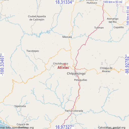
| Map corner | latitude | longitude |
|---|---|---|
| Upper-left | 18.31334°, | -100.33407° |
| Center: | 17.64455°, | -99.63094° |
| Lower-right: | 16.97327°, | -98.92782° |
| Map W x H: | 149×149 km | = 92.6×92.6mi |
| max Lat: | 32.7° ⇑81.8% North |
| Atlixtac: | 17.64455° |
| min Lat: | ⇓18.2% South 14.53588° |
| min Long | Atlixtac | max Long |
| -117.105° | -99.63094° | -86.73105° |
| W 40.9%⇐ | ⇒59.1% E |
Elevation
Elevation of Atlixtac is 1579 m = 5180 ft, and this is 325.3 m = 1067 ft above average elevation for this country.
| Max E: |
3497 m = 11473 ft | 45.3% |
| Atlixtac | 1579 m 5180 ft | |
| Avg. | 1253.7 m = 4113 ft | |
Min E: |
-1 m = -3 ft | 54.7% |
See also: Mexico elevation on elevation.city.
Geographical zone
Atlixtac is located in North Torrid zone (between Equator and Tropic of Cancer). Distance of this Northern Tropic circle is 644 km =400.2 mi to North.| Distance of | km | miles | from Atlixtac |
|---|---|---|---|
| North Pole | 8045.2 | 4999.1 | to North |
| Arctic Circle | 5439.3 | 3379.8 | to North |
| Tropic Cancer | 644 | 400.2 | to North |
| Equator | 1961.9 | 1219.1 | to South |


Nearby cities:
15 places around Atlixtac: (largest is in red/bold)
• Amojileca
10.6 km =6.6 mi,  141°
141°
• Campo de Aviación
20 km =12.4 mi,  274°
274°
• Carrizal de Bravo
22.1 km =13.7 mi,  262°
262°
• Chichihualco
5.1 km =3.2 mi,  288°
288°
• Chilpancingo
16.9 km =10.5 mi,  128°
128°
• El Balzamar
20.4 km =12.7 mi,  247°
247°
• El Naranjo
13.8 km =8.6 mi,  297°
297°
• El Palmar
3 km =1.9 mi,  78°
78°
• Huitziltepec
20.2 km =12.6 mi,  52°
52°
• Iyotla
12.6 km =7.8 mi, 258°
• Puerto General Nicolás Bravo (Filo de Caballos)
22.6 km =14 mi, 270°
• San Vicente
15.5 km =9.6 mi,  201°
201°
• Tepozonalco
12.5 km =7.8 mi, 248°
• Xochipala
18.6 km =11.6 mi,  357°
357°
• Zumpango del Río
11 km =6.8 mi, 84°
Sources, notices
• [Note1] Compared only with cities in Mexico existing in our database
• [Src1] Map data: © OpenStreetMap contributors (CC-BY-SA)
• [Src2] Other city data from geonames.org with taken over terms of usage.
• [Src3] Geographical zone / Annual Mean Temperature by Robert A. Rohde @ Wikipedia
