Morelos geodata
Morelos (Chihuahua) is a seat of a second-order administrative division; located in Mexico in America/Chihuahua (GMT-6) time zone. With population of 813 people, there are 10742 cities with bigger population in this country. Compared to other cities in Mexico, 95.9% of cities are located further ↓South; 95.3% of cities are located further →East and 67.1% of cities have higher elevation than Morelos. Note1


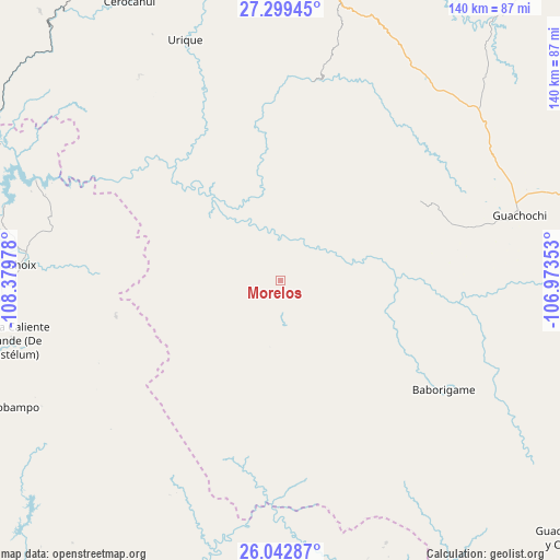
Morelos GPS coordinates[2]
26° 40' 22.404" North, 107° 40' 35.94" West
| Map corner | latitude | longitude |
|---|---|---|
| Upper-left | 27.29945°, | -108.37978° |
| Center: | 26.67289°, | -107.67665° |
| Lower-right: | 26.04287°, | -106.97353° |
| Map W x H: | 139.7×139.7 km | = 86.8×86.8mi |
| max Lat: | 32.7° ⇑4.1% North |
| Morelos: | 26.67289° |
| min Lat: | ⇓95.9% South 14.53588° |
| min Long | Morelos | max Long |
| -117.105° | -107.67665° | -86.73105° |
| W 4.7%⇐ | ⇒95.3% E |
Elevation
Elevation of Morelos is 582 m = 1909 ft, and this is 671.7 m = 2204 ft below average elevation for this country.
| Max E: |
3497 m = 11473 ft | 67.1% |
| Avg. | 1253.7 m = 4113 ft | |
| Morelos | 582 m = 1909 ft | |
Min E: |
-1 m = -3 ft | 32.9% |
See also: Mexico elevation on elevation.city.
Geographical zone
Morelos is located in North temperate zone (between Tropic of Cancer and the Arctic Circle). Distance of this Northern Tropic circle is 359.8 km =223.6 mi to South.| Distance of | km | miles | from Morelos |
|---|---|---|---|
| North Pole | 7041.3 | 4375.3 | to North |
| Arctic Circle | 4435.4 | 2756 | to North |
| Tropic Cancer | 359.8 | 223.6 | to South |
| Equator | 2965.7 | 1842.8 | to South |


Nearby cities:
15 places around Morelos: (largest is in red/bold)
• Agua Caliente Grande (De Gastélum)
68.4 km =42.5 mi,  257°
257°
• Baborigame
48.8 km =30.3 mi,  123°
123°
• Bajosori
71.3 km =44.3 mi,  271°
271°
• Batopilas
40.1 km =24.9 mi,  350°
350°
• Chinobampo
75.3 km =46.8 mi,  245°
245°
• Choix
64.6 km =40.1 mi, 273°
• Guachochi
62 km =38.5 mi,  74°
74°
• Guadalupe
64.1 km =39.8 mi, 264°
• Guapalaina
60.2 km =37.4 mi,  338°
338°
• Polanco (Ranchería Mineral Polanco)
18.3 km =11.4 mi,  12°
12°
• Samachique
71.2 km =44.2 mi, 11°
• San Javier
77.7 km =48.3 mi, 269°
• Santa Ana
71 km =44.1 mi, 262°
• Urique
64.3 km =40 mi, 338°
• Yoquivo
41.6 km =25.8 mi,  19°
19°
Sources, notices
• [Note1] Compared only with cities in Mexico existing in our database
• [Src1] Map data: © OpenStreetMap contributors (CC-BY-SA)
• [Src2] Other city data from geonames.org with taken over terms of usage.
• [Src3] Geographical zone / Annual Mean Temperature by Robert A. Rohde @ Wikipedia
