Lüderitz geodata
Lüderitz (Karas) is a populated place; located in Namibia in Africa/Windhoek (GMT+2) time zone. With population of 15,137 people, there are 13 cities with bigger population in this country. Compared to other cities in Namibia, 93.2% of cities are located further ↑North; 79.5% of cities are located further →East and 100% of cities have higher elevation than Lüderitz. Note1


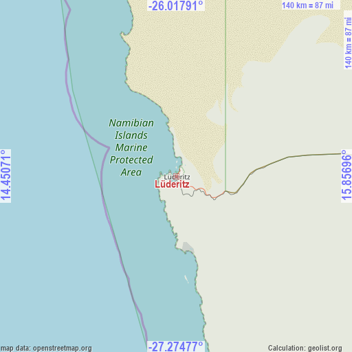
Lüderitz GPS coordinates[2]
26° 38' 53.052" South, 15° 9' 13.788" East
| Map corner | latitude | longitude |
|---|---|---|
| Upper-left | -26.01791°, | 14.45071° |
| Center: | -26.64807°, | 15.15383° |
| Lower-right: | -27.27477°, | 15.85696° |
| Map W x H: | 139.7×139.8 km | = 86.8×86.9mi |
| max Lat: | -17.4° ⇑93.2% North |
| Lüderitz: | -26.64807° |
| min Lat: | ⇓6.8% South -28.55° |
| min Long | Lüderitz | max Long |
| 13.83998° | 15.15383° | 24.26667° |
| W 20.5%⇐ | ⇒79.5% E |
Elevation
Elevation of Lüderitz is 1 m = 3 ft, and this is 1026.8 m = 3369 ft below average elevation for this country.
| Max E: |
1656 m = 5433 ft | 100% |
| Avg. | 1027.8 m = 3372 ft | |
| Lüderitz | 1 m = 3 ft | |
Min E: |
1 m = 3 ft | 0% |
See also: Namibia elevation on elevation.city.
Geographical zone
Lüderitz is located in South temperate zone (between Tropic of Capricorn and the Antarctic Circle). Distance of this Southern Tropic circle is 357.1 km =221.9 mi to North.| Distance of | km | miles | from Lüderitz |
|---|---|---|---|
| Equator | 2963 | 1841.1 | to North |
| Tropic Capricorn | 357.1 | 221.9 | to North |
| Antarctic Circle | 4438.2 | 2757.8 | to South |
| South Pole | 7044.1 | 4377 | to South |


Nearby cities:
10 places around Lüderitz: (largest is in red/bold)
• Bethanie
199.4 km =123.9 mi,  84°
84°
• Hoachanas
420.7 km =261.4 mi,  43°
43°
• Karasburg
386.4 km =240.1 mi,  113°
113°
• Keetmanshoop
296.3 km =184.1 mi,  88°
88°
• Maltahöhe
272.6 km =169.4 mi, 42°
• Mariental
360.1 km =223.8 mi,  51°
51°
• Oranjemund
246.2 km =153 mi,  149°
149°
• Rehoboth
418.6 km =260.1 mi,  27°
27°
• Tses
296.2 km =184.1 mi,  73°
73°
• Walvis Bay
415.5 km =258.2 mi,  350°
350°
Sources, notices
• [Note1] Compared only with cities in Namibia existing in our database
• [Src1] Map data: © OpenStreetMap contributors (CC-BY-SA)
• [Src2] Other city data from geonames.org with taken over terms of usage.
• [Src3] Geographical zone / Annual Mean Temperature by Robert A. Rohde @ Wikipedia
