Mariental geodata
Mariental (Hardap) is a seat of a first-order administrative division; located in Namibia in Africa/Windhoek (GMT+2) time zone. With population of 13,380 people, there are 14 cities with bigger population in this country. Compared to other cities in Namibia, 81.8% of cities are located further ↑North; 72.7% of cities are located further ←West and 52.3% of cities have lower elevation than Mariental. Note1


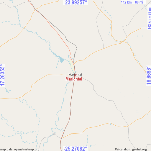
Mariental GPS coordinates[2]
24° 37' 59.988" South, 17° 58' 0.012" East
| Map corner | latitude | longitude |
|---|---|---|
| Upper-left | -23.99257°, | 17.26355° |
| Center: | -24.63333°, | 17.96667° |
| Lower-right: | -25.27082°, | 18.6698° |
| Map W x H: | 142.1×142.1 km | = 88.3×88.3mi |
| max Lat: | -17.4° ⇑81.8% North |
| Mariental: | -24.63333° |
| min Lat: | ⇓18.2% South -28.55° |
| min Long | Mariental | max Long |
| 13.83998° | 17.96667° | 24.26667° |
| W 72.7%⇐ | ⇒27.3% E |
Elevation
Elevation of Mariental is 1106 m = 3629 ft, and this is 78.2 m = 257 ft above average elevation for this country.
| Max E: |
1656 m = 5433 ft | 47.7% |
| Mariental | 1106 m 3629 ft | |
| Avg. | 1027.8 m = 3372 ft | |
Min E: |
1 m = 3 ft | 52.3% |
See also: Namibia elevation on elevation.city.
Geographical zone
Mariental is located in South temperate zone (between Tropic of Capricorn and the Antarctic Circle). Distance of this Southern Tropic circle is 133.1 km =82.7 mi to North.| Distance of | km | miles | from Mariental |
|---|---|---|---|
| Equator | 2739 | 1701.9 | to North |
| Tropic Capricorn | 133.1 | 82.7 | to North |
| Antarctic Circle | 4662.2 | 2897 | to South |
| South Pole | 7268.1 | 4516.2 | to South |


Nearby cities:
15 places around Mariental: (largest is in red/bold)
• Aranos
129.1 km =80.2 mi,  64°
64°
• Bethanie
221.4 km =137.6 mi,  201°
201°
• Gobabis
263.3 km =163.6 mi,  22°
22°
• Hoachanas
80.1 km =49.8 mi,  6°
6°
• Karibib
370.9 km =230.5 mi,  324°
324°
• Katutura
252.2 km =156.7 mi,  338°
338°
• Keetmanshoop
217.5 km =135.1 mi,  175°
175°
• Lüderitz
360.1 km =223.8 mi,  231°
231°
• Maltahöhe
101.8 km =63.3 mi,  257°
257°
• Okahandja
313.5 km =194.8 mi, 340°
• Otjimbingwe
315.3 km =195.9 mi, 323°
• Rehoboth
171.3 km =106.4 mi,  328°
328°
• Tses
139 km =86.4 mi, 178°
• Usakos
379.6 km =235.9 mi, 320°
• Windhoek
247.5 km =153.8 mi, 338°
Sources, notices
• [Note1] Compared only with cities in Namibia existing in our database
• [Src1] Map data: © OpenStreetMap contributors (CC-BY-SA)
• [Src2] Other city data from geonames.org with taken over terms of usage.
• [Src3] Geographical zone / Annual Mean Temperature by Robert A. Rohde @ Wikipedia
