Walvis Bay geodata
Walvis Bay (Erongo) is a populated place; located in Namibia in Africa/Windhoek (GMT+2) time zone. With population of 52,058 people, there are 2 cities with bigger population in this country. Compared to other cities in Namibia, 72.7% of cities are located further ↑North; 95.5% of cities are located further →East and 97.7% of cities have higher elevation than Walvis Bay. Note1


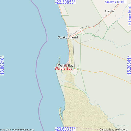
Walvis Bay GPS coordinates[2]
22° 57' 27" South, 14° 30' 19.008" East
| Map corner | latitude | longitude |
|---|---|---|
| Upper-left | -22.30853°, | 13.80216° |
| Center: | -22.9575°, | 14.50528° |
| Lower-right: | -23.60337°, | 15.20841° |
| Map W x H: | 144×144 km | = 89.5×89.5mi |
| max Lat: | -17.4° ⇑72.7% North |
| Walvis Bay: | -22.9575° |
| min Lat: | ⇓27.3% South -28.55° |
| min Long | Walvis Bay | max Long |
| 13.83998° | 14.50528° | 24.26667° |
| W 4.5%⇐ | ⇒95.5% E |
Elevation
Elevation of Walvis Bay is 6 m = 20 ft, and this is 1021.8 m = 3352 ft below average elevation for this country.
| Max E: |
1656 m = 5433 ft | 97.7% |
| Avg. | 1027.8 m = 3372 ft | |
| Walvis Bay | 6 m = 20 ft | |
Min E: |
1 m = 3 ft | 2.3% |
See also: Walvis Bay elevation on elevation.city.
Geographical zone
Walvis Bay is located in South Torrid zone (between Equator and Tropic of Capricorn). Distance of this Southern Tropic circle is 53.3 km =33.1 mi to South.| Distance of | km | miles | from Walvis Bay |
|---|---|---|---|
| Equator | 2552.6 | 1586.1 | to North |
| Tropic Capricorn | 53.3 | 33.1 | to South |
| Antarctic Circle | 4848.5 | 3012.7 | to South |
| South Pole | 7454.4 | 4631.9 | to South |


Nearby cities:
15 places around Walvis Bay: (largest is in red/bold)
• Arandis
76.5 km =47.5 mi,  38°
38°
• Hentiesbaai
96.2 km =59.8 mi,  346°
346°
• Karibib
177.7 km =110.4 mi,  50°
50°
• Katutura
266.4 km =165.5 mi,  79°
79°
• Khorixas
292 km =181.4 mi,  9°
9°
• Maltahöhe
327 km =203.2 mi,  129°
129°
• Okahandja
270.4 km =168 mi,  66°
66°
• Omaruru
224.4 km =139.4 mi, 40°
• Otjimbingwe
180.2 km =112 mi, 67°
• Otjiwarongo
354.8 km =220.5 mi, 38°
• Outjo
358.8 km =222.9 mi,  28°
28°
• Rehoboth
267.3 km =166.1 mi,  98°
98°
• Swakopmund
31.1 km =19.3 mi,  4°
4°
• Usakos
154.9 km =96.3 mi, 46°
• Windhoek
268 km =166.5 mi, 80°
Sources, notices
• [Note1] Compared only with cities in Namibia existing in our database
• [Src1] Map data: © OpenStreetMap contributors (CC-BY-SA)
• [Src2] Other city data from geonames.org with taken over terms of usage.
• [Src3] Geographical zone / Annual Mean Temperature by Robert A. Rohde @ Wikipedia
