Tchintabaraden geodata
Tchintabaraden (Tahoua) is a seat of a second-order administrative division; located in Niger in Africa/Niamey (GMT+1) time zone. With population of 8,851 people, there are 34 cities with bigger population in this country. Compared to other cities in Niger, 88.4% of cities are located further ↓South; 60.5% of cities are located further →East and 74.4% of cities have lower elevation than Tchintabaraden. Note1


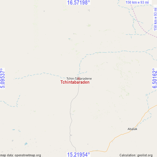
Tchintabaraden GPS coordinates[2]
15° 53' 48.84" North, 5° 47' 54.6" East
| Map corner | latitude | longitude |
|---|---|---|
| Upper-left | 16.57198°, | 5.09537° |
| Center: | 15.8969°, | 5.7985° |
| Lower-right: | 15.21954°, | 6.50162° |
| Map W x H: | 150.4×150.4 km | = 93.5×93.5mi |
| max Lat: | 18.73694° ⇑11.6% North |
| Tchintabaraden: | 15.8969° |
| min Lat: | ⇓88.4% South 11.88435° |
| min Long | Tchintabaraden | max Long |
| 0.75306° | 5.7985° | 13.10921° |
| W 39.5%⇐ | ⇒60.5% E |
Elevation
Elevation of Tchintabaraden is 419 m = 1375 ft, and this is 76.2 m = 250 ft above average elevation for this country.
| Max E: |
525 m = 1722 ft | 25.6% |
| Tchintabaraden | 419 m 1375 ft | |
| Avg. | 342.8 m = 1125 ft | |
Min E: |
177 m = 581 ft | 74.4% |
See also: Niger elevation on elevation.city.
Geographical zone
Tchintabaraden is located in North Torrid zone (between Equator and Tropic of Cancer). Distance of this Northern Tropic circle is 838.3 km =520.9 mi to North.| Distance of | km | miles | from Tchintabaraden |
|---|---|---|---|
| North Pole | 8239.5 | 5119.8 | to North |
| Arctic Circle | 5633.6 | 3500.6 | to North |
| Tropic Cancer | 838.3 | 520.9 | to North |
| Equator | 1767.6 | 1098.3 | to South |


Nearby cities:
15 places around Tchintabaraden: (largest is in red/bold)
• Abalak
71.5 km =44.4 mi,  133°
133°
• Agadez
262.7 km =163.2 mi,  62°
62°
• Alaghsas
267.4 km =166.2 mi, 62°
• Birni N Konni
240.9 km =149.7 mi,  194°
194°
• Bouza
166 km =103.1 mi,  170°
170°
• Dakoro
185.8 km =115.5 mi,  146°
146°
• Guidan Roumdji
267 km =165.9 mi,  158°
158°
• Illéla
170.4 km =105.9 mi,  200°
200°
• Keïta
127 km =78.9 mi,  181°
181°
• Madaoua
203.5 km =126.4 mi, 175°
• Maradi
301.1 km =187.1 mi, 152°
• Mayahi
295.1 km =183.4 mi,  137°
137°
• Tahoua
125.6 km =78 mi,  206°
206°
• Tchirozérine
255.8 km =158.9 mi,  54°
54°
• Tibiri
292.3 km =181.6 mi, 152°
Sources, notices
• [Note1] Compared only with cities in Niger existing in our database
• [Src1] Map data: © OpenStreetMap contributors (CC-BY-SA)
• [Src2] Other city data from geonames.org with taken over terms of usage.
• [Src3] Geographical zone / Annual Mean Temperature by Robert A. Rohde @ Wikipedia
