Abalak geodata
Abalak (Tahoua) is a seat of a second-order administrative division; located in Niger in Africa/Niamey (GMT+1) time zone. With population of 13,555 people, there are 26 cities with bigger population in this country. Compared to other cities in Niger, 86% of cities are located further ↓South; 53.5% of cities are located further →East and 83.7% of cities have lower elevation than Abalak. Note1


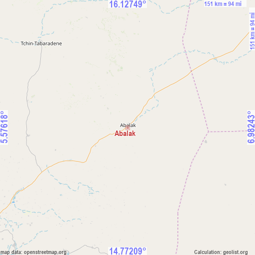
Abalak GPS coordinates[2]
15° 27' 3.24" North, 6° 16' 45.48" East
| Map corner | latitude | longitude |
|---|---|---|
| Upper-left | 16.12749°, | 5.57618° |
| Center: | 15.4509°, | 6.2793° |
| Lower-right: | 14.77209°, | 6.98243° |
| Map W x H: | 150.7×150.7 km | = 93.6×93.6mi |
| max Lat: | 18.73694° ⇑14% North |
| Abalak: | 15.4509° |
| min Lat: | ⇓86% South 11.88435° |
| min Long | Abalak | max Long |
| 0.75306° | 6.2793° | 13.10921° |
| W 46.5%⇐ | ⇒53.5% E |
Elevation
Elevation of Abalak is 439 m = 1440 ft, and this is 96.2 m = 316 ft above average elevation for this country.
| Max E: |
525 m = 1722 ft | 16.3% |
| Abalak | 439 m 1440 ft | |
| Avg. | 342.8 m = 1125 ft | |
Min E: |
177 m = 581 ft | 83.7% |
See also: Niger elevation on elevation.city.
Geographical zone
Abalak is located in North Torrid zone (between Equator and Tropic of Cancer). Distance of this Northern Tropic circle is 887.9 km =551.7 mi to North.| Distance of | km | miles | from Abalak |
|---|---|---|---|
| North Pole | 8289.1 | 5150.6 | to North |
| Arctic Circle | 5683.2 | 3531.4 | to North |
| Tropic Cancer | 887.9 | 551.7 | to North |
| Equator | 1718 | 1067.5 | to South |


Nearby cities:
15 places around Abalak: (largest is in red/bold)
• Agadez
249.1 km =154.8 mi,  47°
47°
• Alaghsas
254.5 km =158.1 mi, 46°
• Birni N Konni
214.7 km =133.4 mi,  211°
211°
• Bouza
117.1 km =72.8 mi,  192°
192°
• Dakoro
116.8 km =72.6 mi,  153°
153°
• Guidan Roumdji
204.4 km =127 mi,  167°
167°
• Illéla
156.5 km =97.2 mi,  225°
225°
• Keïta
94.4 km =58.7 mi, 214°
• Madaoua
157 km =97.6 mi, 192°
• Maradi
234.3 km =145.6 mi,  157°
157°
• Mayahi
223.7 km =139 mi,  138°
138°
• Tahoua
125.1 km =77.7 mi,  240°
240°
• Tchintabaraden
71.5 km =44.4 mi,  313°
313°
• Tchirozérine
252.5 km =156.9 mi,  38°
38°
• Tibiri
225.7 km =140.2 mi, 158°
Sources, notices
• [Note1] Compared only with cities in Niger existing in our database
• [Src1] Map data: © OpenStreetMap contributors (CC-BY-SA)
• [Src2] Other city data from geonames.org with taken over terms of usage.
• [Src3] Geographical zone / Annual Mean Temperature by Robert A. Rohde @ Wikipedia
