Illéla geodata
Illéla (Tahoua) is a seat of a second-order administrative division; located in Niger in Africa/Niamey (GMT+1) time zone. With population of 16,678 people, there are 23 cities with bigger population in this country. Compared to other cities in Niger, 72.1% of cities are located further ↓South; 69.8% of cities are located further →East and 65.1% of cities have higher elevation than Illéla. Note1


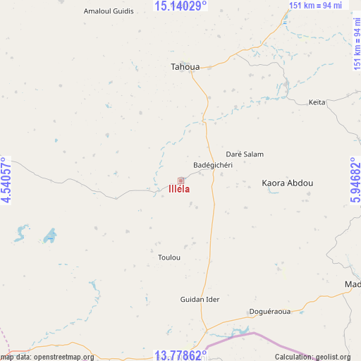
Illéla GPS coordinates[2]
14° 27' 37.8" North, 5° 14' 37.32" East
| Map corner | latitude | longitude |
|---|---|---|
| Upper-left | 15.14029°, | 4.54057° |
| Center: | 14.4605°, | 5.2437° |
| Lower-right: | 13.77862°, | 5.94682° |
| Map W x H: | 151.4×151.4 km | = 94.1×94.1mi |
| max Lat: | 18.73694° ⇑27.9% North |
| Illéla: | 14.4605° |
| min Lat: | ⇓72.1% South 11.88435° |
| min Long | Illéla | max Long |
| 0.75306° | 5.2437° | 13.10921° |
| W 30.2%⇐ | ⇒69.8% E |
Elevation
Elevation of Illéla is 307 m = 1007 ft, and this is 35.8 m = 117 ft below average elevation for this country.
| Max E: |
525 m = 1722 ft | 65.1% |
| Avg. | 342.8 m = 1125 ft | |
| Illéla | 307 m = 1007 ft | |
Min E: |
177 m = 581 ft | 34.9% |
See also: Niger elevation on elevation.city.
Geographical zone
Illéla is located in North Torrid zone (between Equator and Tropic of Cancer). Distance of this Northern Tropic circle is 998.1 km =620.2 mi to North.| Distance of | km | miles | from Illéla |
|---|---|---|---|
| North Pole | 8399.2 | 5219 | to North |
| Arctic Circle | 5793.3 | 3599.8 | to North |
| Tropic Cancer | 998.1 | 620.2 | to North |
| Equator | 1607.9 | 999.1 | to South |


Nearby cities:
15 places around Illéla: (largest is in red/bold)
• Abalak
156.5 km =97.2 mi,  45°
45°
• Birni N Konni
73.9 km =45.9 mi,  179°
179°
• Bouza
86.1 km =53.5 mi,  92°
92°
• Dakoro
163.9 km =101.8 mi, 88°
• Dogondoutchi
159.9 km =99.4 mi,  235°
235°
• Filingué
207.9 km =129.2 mi,  266°
266°
• Guidan Roumdji
180.3 km =112 mi,  119°
119°
• Keïta
65.9 km =40.9 mi,  60°
60°
• Loga
236.2 km =146.8 mi,  246°
246°
• Madaoua
88.4 km =54.9 mi, 119°
• Madarounfa
242.9 km =150.9 mi, 121°
• Maradi
227.1 km =141.1 mi, 118°
• Tahoua
47.7 km =29.6 mi,  3°
3°
• Tchintabaraden
170.4 km =105.9 mi,  20°
20°
• Tibiri
218.8 km =136 mi, 117°
Sources, notices
• [Note1] Compared only with cities in Niger existing in our database
• [Src1] Map data: © OpenStreetMap contributors (CC-BY-SA)
• [Src2] Other city data from geonames.org with taken over terms of usage.
• [Src3] Geographical zone / Annual Mean Temperature by Robert A. Rohde @ Wikipedia
