Keïta geodata
Keïta (Tahoua) is a seat of a second-order administrative division; located in Niger in Africa/Niamey (GMT+1) time zone. With population of 8,960 people, there are 33 cities with bigger population in this country. Compared to other cities in Niger, 79.1% of cities are located further ↓South; 62.8% of cities are located further →East and 60.5% of cities have lower elevation than Keïta. Note1


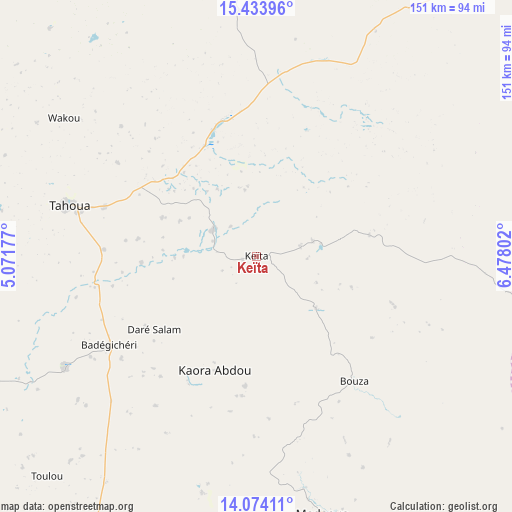
Keïta GPS coordinates[2]
14° 45' 18.36" North, 5° 46' 29.64" East
| Map corner | latitude | longitude |
|---|---|---|
| Upper-left | 15.43396°, | 5.07177° |
| Center: | 14.7551°, | 5.7749° |
| Lower-right: | 14.07411°, | 6.47802° |
| Map W x H: | 151.2×151.2 km | = 94×94mi |
| max Lat: | 18.73694° ⇑20.9% North |
| Keïta: | 14.7551° |
| min Lat: | ⇓79.1% South 11.88435° |
| min Long | Keïta | max Long |
| 0.75306° | 5.7749° | 13.10921° |
| W 37.2%⇐ | ⇒62.8% E |
Elevation
Elevation of Keïta is 395 m = 1296 ft, and this is 52.2 m = 171 ft above average elevation for this country.
| Max E: |
525 m = 1722 ft | 39.5% |
| Keïta | 395 m 1296 ft | |
| Avg. | 342.8 m = 1125 ft | |
Min E: |
177 m = 581 ft | 60.5% |
See also: Niger elevation on elevation.city.
Geographical zone
Keïta is located in North Torrid zone (between Equator and Tropic of Cancer). Distance of this Northern Tropic circle is 965.3 km =599.8 mi to North.| Distance of | km | miles | from Keïta |
|---|---|---|---|
| North Pole | 8366.4 | 5198.6 | to North |
| Arctic Circle | 5760.6 | 3579.5 | to North |
| Tropic Cancer | 965.3 | 599.8 | to North |
| Equator | 1640.6 | 1019.4 | to South |


Nearby cities:
15 places around Keïta: (largest is in red/bold)
• Abalak
94.4 km =58.7 mi,  34°
34°
• Aguié
256.8 km =159.6 mi,  122°
122°
• Birni N Konni
120.7 km =75 mi,  207°
207°
• Bouza
46.9 km =29.1 mi,  142°
142°
• Dakoro
109.9 km =68.3 mi,  104°
104°
• Dogondoutchi
225.6 km =140.2 mi,  236°
236°
• Guidan Roumdji
157.3 km =97.7 mi, 140°
• Illéla
65.9 km =40.9 mi, 240°
• Madaoua
78.4 km =48.7 mi,  165°
165°
• Madarounfa
219.2 km =136.2 mi, 137°
• Maradi
199.9 km =124.2 mi,  134°
134°
• Mayahi
222.8 km =138.4 mi,  113°
113°
• Tahoua
56.4 km =35 mi,  285°
285°
• Tchintabaraden
127 km =78.9 mi,  1°
1°
• Tibiri
190.9 km =118.6 mi, 133°
Sources, notices
• [Note1] Compared only with cities in Niger existing in our database
• [Src1] Map data: © OpenStreetMap contributors (CC-BY-SA)
• [Src2] Other city data from geonames.org with taken over terms of usage.
• [Src3] Geographical zone / Annual Mean Temperature by Robert A. Rohde @ Wikipedia
