Tahoua geodata
Tahoua is a seat of a first-order administrative division; located in Niger in Africa/Niamey (GMT+1) time zone. With population of 80,425 people, there are 5 cities with bigger population in this country. Compared to other cities in Niger, 81.4% of cities are located further ↓South; 65.1% of cities are located further →East and 55.8% of cities have lower elevation than Tahoua. Note1


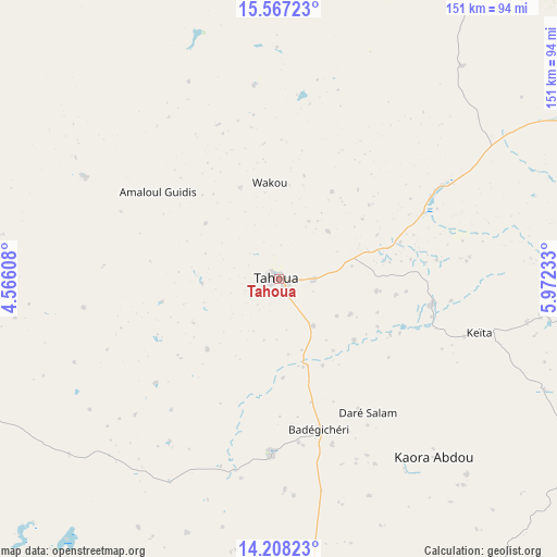
Tahoua GPS coordinates[2]
14° 53' 19.68" North, 5° 16' 9.12" East
| Map corner | latitude | longitude |
|---|---|---|
| Upper-left | 15.56723°, | 4.56608° |
| Center: | 14.8888°, | 5.2692° |
| Lower-right: | 14.20823°, | 5.97233° |
| Map W x H: | 151.1×151.1 km | = 93.9×93.9mi |
| max Lat: | 18.73694° ⇑18.6% North |
| Tahoua: | 14.8888° |
| min Lat: | ⇓81.4% South 11.88435° |
| min Long | Tahoua | max Long |
| 0.75306° | 5.2692° | 13.10921° |
| W 34.9%⇐ | ⇒65.1% E |
Elevation
Elevation of Tahoua is 389 m = 1276 ft, and this is 46.2 m = 152 ft above average elevation for this country.
| Max E: |
525 m = 1722 ft | 44.2% |
| Tahoua | 389 m 1276 ft | |
| Avg. | 342.8 m = 1125 ft | |
Min E: |
177 m = 581 ft | 55.8% |
See also: Tahoua elevation on elevation.city.
Geographical zone
Tahoua is located in North Torrid zone (between Equator and Tropic of Cancer). Distance of this Northern Tropic circle is 950.4 km =590.6 mi to North.| Distance of | km | miles | from Tahoua |
|---|---|---|---|
| North Pole | 8351.6 | 5189.4 | to North |
| Arctic Circle | 5745.7 | 3570.2 | to North |
| Tropic Cancer | 950.4 | 590.6 | to North |
| Equator | 1655.5 | 1028.7 | to South |


Nearby cities:
15 places around Tahoua: (largest is in red/bold)
• Abalak
125.1 km =77.7 mi,  60°
60°
• Birni N Konni
121.5 km =75.5 mi,  180°
180°
• Bouza
98 km =60.9 mi,  121°
121°
• Dakoro
166.3 km =103.3 mi,  104°
104°
• Dogondoutchi
192.9 km =119.9 mi,  223°
223°
• Filingué
218.4 km =135.7 mi,  254°
254°
• Guidan Roumdji
205.8 km =127.9 mi,  131°
131°
• Illéla
47.7 km =29.6 mi, 183°
• Keïta
56.4 km =35 mi,  105°
105°
• Loga
261 km =162.2 mi,  237°
237°
• Madaoua
117.3 km =72.9 mi,  140°
140°
• Madarounfa
268.8 km =167 mi, 130°
• Maradi
250.7 km =155.8 mi, 128°
• Tchintabaraden
125.6 km =78 mi,  26°
26°
• Tibiri
241.9 km =150.3 mi, 127°
Sources, notices
• [Note1] Compared only with cities in Niger existing in our database
• [Src1] Map data: © OpenStreetMap contributors (CC-BY-SA)
• [Src2] Other city data from geonames.org with taken over terms of usage.
• [Src3] Geographical zone / Annual Mean Temperature by Robert A. Rohde @ Wikipedia
